
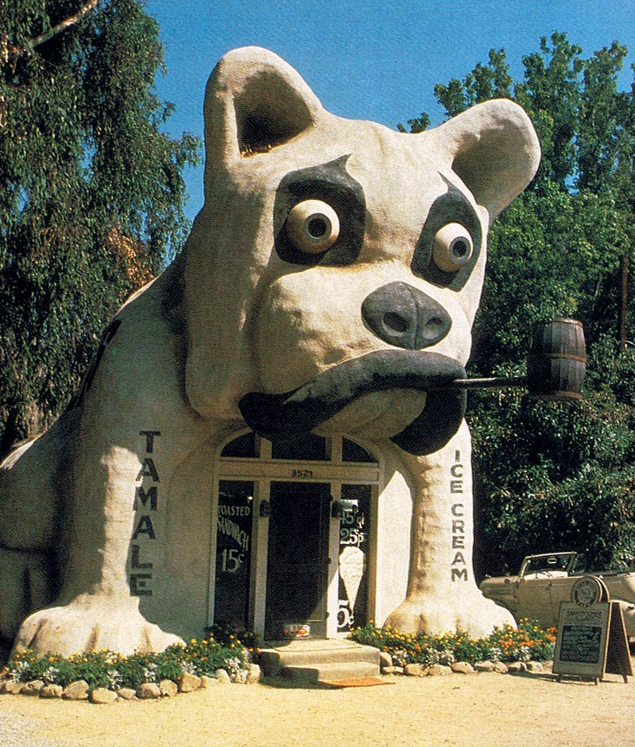
A bulldog-shaped restaurant that stood on Valley Boulevard in Rosemead, California from approximately 1931 to 1944, when it was moved to nearby Monterey Park and used as a real estate office for the Great Western Development Company. By 1949, it was gone.
For many years, “1153 West Washington Boulevard, Los Angeles” was given as the Bulldog’s address in all publications. This turned out to be incorrect.
Around 1931,1 the Bulldog opened on 1153 East Valley Boulevard, Rosemead, California. Its original owner was Everett Floyd Maddox, whose father Joseph Maddox owned the similar “Pup Cafe” on West Adams Boulevard in Los Angeles.

Everett Maddox and family, 1925. Everett is on the far left. Source: Ancestry.
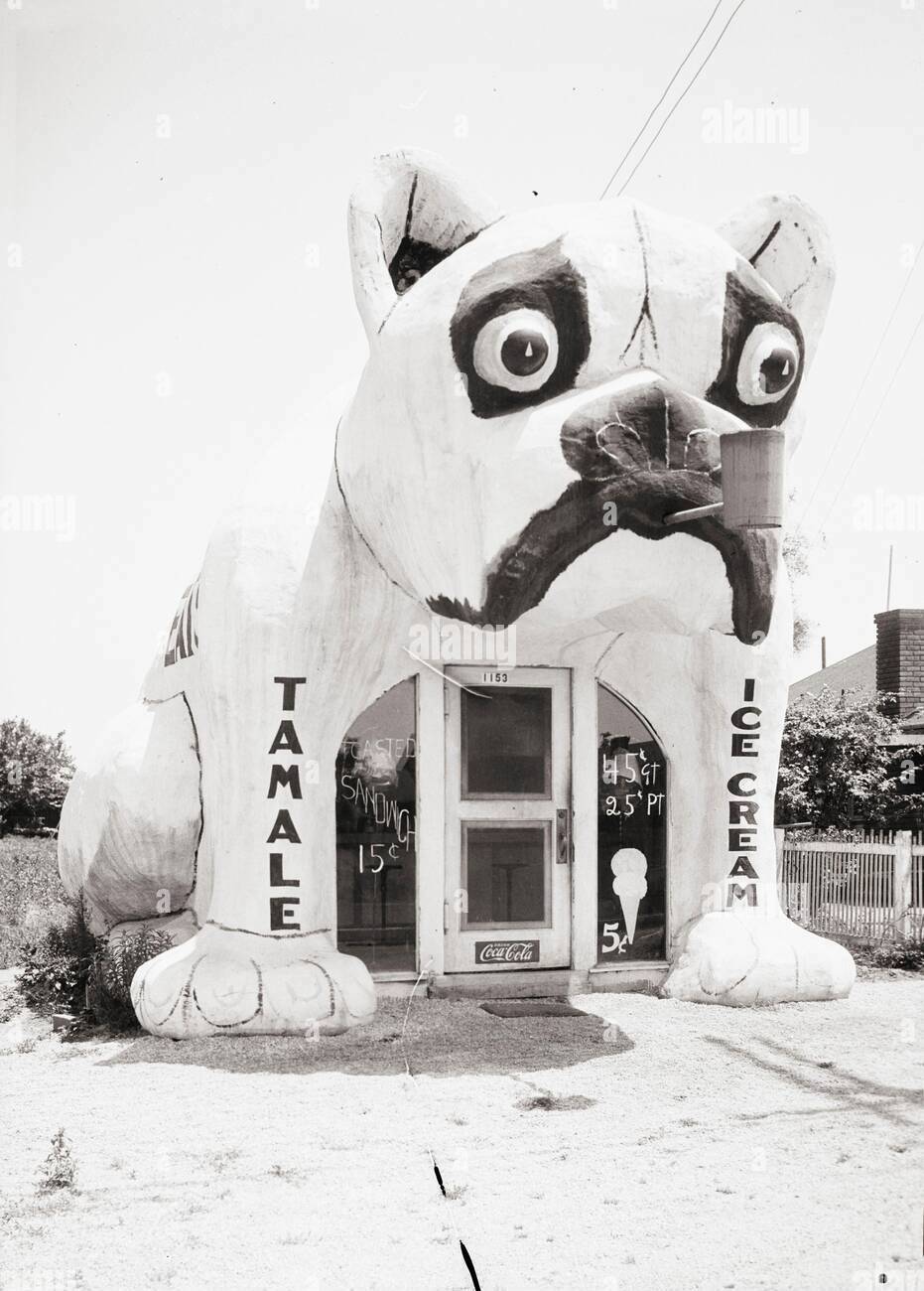
“Bulldog Inn Photo 1,” c. 1931.2 Source: Alamy Stock Photo.
The above photo may be the oldest one that survives of the Bulldog, if the 1931 date is accurate.
The window advertisements for toasted sandwiches and ice cream in this photo have shown up in many depictions and replicas of the Bulldog. It might have surprised the original painter of those advertisements to know how long they would live on. And of course, note the “1153” address number on the Bulldog’s door.
The Bulldog appeared in the 1931 Alhambra-area city directory,3 under “Restaurants and Lunch Rooms: Rosemead.” It was listed with no identification beyond Everett Maddox’s name.

1931 Alhambra-area city directory, page 897 (detail). Click image for full page.
It was also included in the directory’s alphabetical listing of all Rosemead businesses and residents. The entry notes that Everett Maddox (and his wife Ruama) are residents of San Gabriel.

1931 Alhambra-area city directory, page 606 (detail). Click image for full page.
This brings us to the question of where exactly the address “1153 East Valley Boulevard, Rosemead” pointed to in 1931. It’s not completely trivial because today there’s no building with that exact address. In fact, at some point after the Bulldog’s existence (likely when Rosemead was incorporated as a city in 1959), the portion of Valley Boulevard running through Rosemead was renumbered and no longer followed the addressing scheme used in neighboring Alhambra and San Gabriel. To make sense of the old address, I looked at a Los Angeles atlas from 1943. The section below shows addresses on East Valley Boulevard starting with 100 at Del Mar Avenue, then counting upward to the east: 400, 500, 600, 800, 850, 1000, 1100, 1200, 1300, 1400. The diagonal dotted line in the “H-1” sector is the Rubio Wash. 1153 East Valley Boulevard would have been right past that dotted line, near the intersection of East Valley Boulevard and Walnut Grove Avenue. Other photos of the Bulldog show the San Gabriel Mountains in the background, confirming that it was on the north side of the street.4 The Bulldog’s location is marked with a blue dot on the map below.
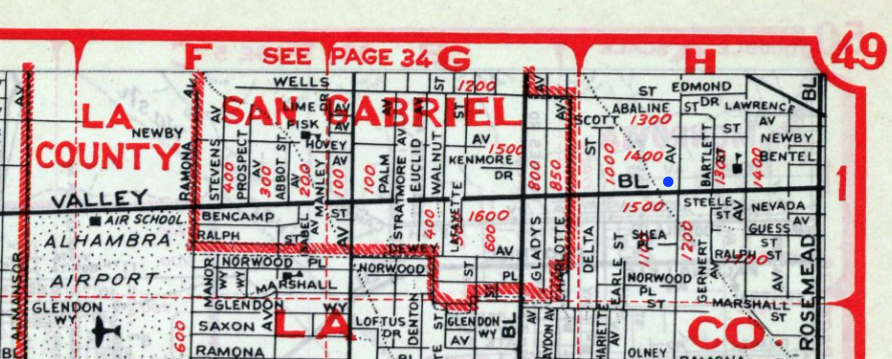
1943 Los Angeles atlas, page 49 (detail). Source: Historic Map Works.
As it turns out, because of how Google Maps makes a best guess at the location of nonexistent addresses, typing “1153 East Valley Boulevard, Rosemead” into Google Maps today will still land you in pretty much the correct spot (although you must specify “Rosemead.”) The real address at that approximate location today is 8547 East Valley Boulevard, Rosemead, California.
The following photo was probably taken around the same time as Photo 1; it’s the only other photo of the Bulldog where the restaurant’s front stoop is a concrete slab, not brick.
“Bulldog Inn Photo 2.” Source: Jim Heimann Collection, posted by Idle Hour bar on Instagram.
In May 1932, the Bulldog was photographed again. The two pictures below would end up in the UCLA Library’s Ralph D. Cornell Historical Papers Collection as part of a collage.5 The collage’s caption places the Bulldog on “Valley Blvd., Alhambra.”6 This is slightly off from the Bulldog’s actual location of Rosemead, but since Rosemead wasn’t even incorporated yet, using the name of a nearby major city was reasonable.

“Bulldog Inn Photo 3,” dated May 15, 1932. Source: UCLA Ralph D. Cornell Historical Papers Collection.
Note the transmission tower in the background of the above photo.

“Bulldog Inn Photo 4,” dated May 15, 1932. Source: UCLA Ralph D. Cornell Historical Papers Collection.
I don’t know of any contemporary outlets that published the following photo of the Bulldog. However, it was eventually printed on a postcard in 1996, with a caption that dated it to February 1933. A date that specific seems like it would have come from a note on the original photo.
Photo 5 gives us a good look at the San Gabriel Mountains in the distance behind the Bulldog, as well as Valley Boulevard itself.
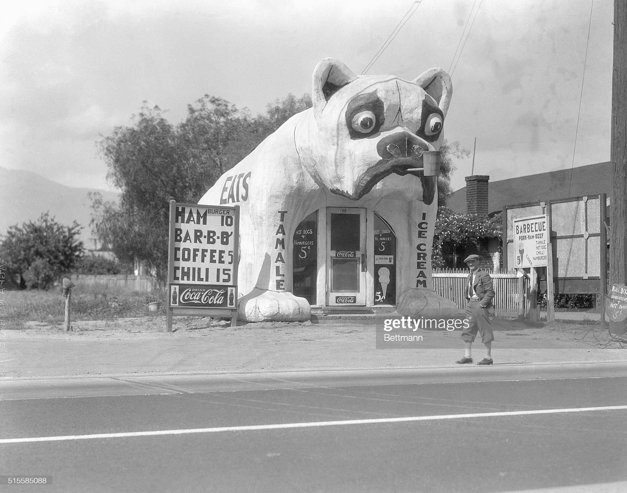
“Bulldog Inn Photo 5,” dated February 3, 1933. Source: Getty Images.
Another useful artifact dating to 1933 is a detailed land-use map of Rosemead. Below is the section of the map corresponding to the Bulldog’s neighborhood.

1933 Rosemead land-use map (detail). Valley Boulevard runs from left to right about halfway down the image. Walnut Grove Avenue runs down the right-hand side. Source: Huntington Library.
On the full map, the wide purple strip reads can be seen to read “Southern California Edison Company Right of Way.” This is land used by the Edison power company for their transmission towers, which are of course visible in several photos of the Bulldog. Perhaps unsurprisingly, the same land is still used by Edison for transmission towers today.
Zooming in even more on the land-use map, we can read the labels from the Bulldog’s exact location:

1933 Rosemead land-use map (detail). The intersection of East Valley Boulevard and Walnut Grove Avenue is on the right.
From left to right, top to bottom, the captions read: “[illegible] Stand,” “Grapes,” “Lunch stand – [illegible],” “Lunch stand,” “Ser. Sta.,” “Real Estate office,” “Chickens,” and “Service Station.” A 1938 aerial photo of the Bulldog (see further down) would make it clear that the Bulldog was the building labeled “Lunch stand – [illegible]” on this map, so the illegible word is probably “Dog.”7
The “Real Estate office” shown on the map is probably the “Tift Realty Co,” which was listed at 1140 East Valley Boulevard in the 1932 Rosemead city directory. This will be notable as we look at the following photo, which appeared in the November 1934 issue of National Geographic.

“Bulldog Inn Photo 6.” Source: National Geographic, volume LXVI, no. 5 (November 1934), page 554. From the article “Southern California at Work” by Frederick Simpich.8 Photograph by Alexander Wiederseder.9 Click image for full page.
This photo was republished by National Geographic and various other sources several times over the years. Significantly, the December 2014 issue of National Geographic reproduced it at a much higher resolution. Now, if we zoom into that photo and take a closer look at the reflection in the Bulldog’s left front window (below), we can see the flipped letters “REALT.” What could that be but the aforementioned Tift Realty Co., across the street?

Bulldog Inn Photo 6, detail. Source: National Geographic, December 2014, page 43. From the article “The Joy of Food: Bringing Family and Friends Together” by Victoria Pope. Image artificially brightened by me to make the text more visible.
I think it’s actually possible that Photo 6 was taken earlier than Photos 3, 4, and 5; it seems to show a less elaborate version of the “HAMburger / BAR-B-Q / COFFEE / CHILI” sign seen in Photos 4 and 5, with a lower price for chili as well. Ultimately, all we know is that Photo 6 was taken at some point before November 1934, when it appeared in print.
The above photographs all show the Bulldog looking more or less exactly how it would be remembered after its destruction. Throughout the rest of the 1930s, its appearance would deteriorate slightly from this ideal.
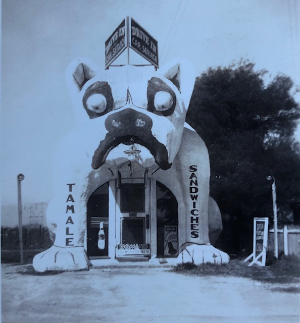
“Bulldog Inn Photo 7.” Source: Jim Heimann Collection, via email.
The above photograph was clearly taken after Photos 1-6. The “Ice Cream” text on the Bulldog’s right leg has been changed to “Sandwiches,” a sign advertising “Drive In Car Service” has been added to the Bulldog’s head, and the Bulldog’s distinctive pipe is gone. There’s no date associated with this photo anywhere and “c. 1937” is just a guess based on the Bulldog’s appearance relative to other photos.
The Bulldog appeared in the 1937 Alhambra-area city directory,10 under “Restaurants and Lunch Rooms: Rosemead.” For the first time, it was identified as the “Bulldog Inn.”

1937 Alhambra-area city directory, page 943 (detail). Click image for full page.
It was also included in the directory’s alphabetical listing of all Rosemead businesses and residents. This entry also clarified that the Bulldog Inn was now owned by three members of the Sadler family. The Sadlers were also listed as residents at the Bulldog’s address (signified by the “r”), in contrast to Everett Maddox, who had lived elsewhere in San Gabriel.

1937 Alhambra-area city directory, page 645 (detail). Click image for full page.
Finally, the Sadlers’ individual listings in that same section included their full names. Note that “r” means “resident of,” suggesting that the Sadlers may have lived next to the Bulldog in addition to owning it.

1937 Alhambra-area city directory, page 673 (detail). Click image for full page.
Photo 8 doesn’t show too many differences from Photo 7, except that there’s now a “For Rent” sign in the Bulldog’s window:

“Bulldog Inn Photo 8,” dated 1938. Source: CSU Dominguez Hills Tomoji Wada Family Papers Collection.
Also taken in 1938 was an aerial photo of Rosemead that gives us a very fuzzy look at the Bulldog, the buildings next to it, and the fields behind it. East Valley Boulevard is the street running from left to right at the bottom. Walnut Grove Avenue runs down the right-hand side.

Rosemead aerial photo, 1938. Source: UCSB Map and Imagery Lab, Flight C-5364, Frame 16.
Two transmission towers are visible at the top right. It’s easier to see their shadows than the towers themselves:

Rosemead aerial photo, 1938, detail.
Now, a closer look at just the Bulldog and the buildings next to it:

Rosemead aerial photo, 1938, detail.
The white blob that I’ve indicated with a red square is likely the Bulldog itself. Also note the dividing line on Valley Boulevard and how the Bulldog is closer to the street than the house on its right, just as seen in the ground-level photographs.
In 1940, the Bulldog was advertised under “Business Opportunities” in the Los Angeles Times classified ads.
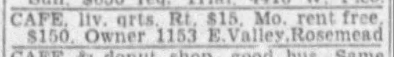
Source: Los Angeles Times, June 16, 1940, part II-A, page 3, fourth column from left.
I won’t claim to understand all the nuances of the ad, but it seems that the Bulldog’s current owners (perhaps still the Sadler family), who shared an address with the restaurant itself, were looking for people to run the restaurant.
This photograph gives us the best view of the Bulldog’s surrounding environment:

“Bulldog Inn Photo 9,” dated September 30, 1940. Source: Jim Heimann Collection.11
There’s a copy of Photo 9 hanging at the Idle Hour bar in North Hollywood, Los Angeles, which is cropped to just show the Bulldog but is higher-resolution than the version Mr. Heimann emailed me. This sharper version reveals some interesting details (see below). I included a close-up of the Bulldog’s head to compensate for the glare on the larger photo.

Bulldog Inn Photo 9, details.
“Tamale” is gone from the Bulldog’s left leg and “Sandwiches” has been rewritten in a different font. There’s a clock mounted on the Bulldog’s forehead (showing that the picture was taken at about 2:55 PM). Most interestingly, there’s a sign in the Bulldog’s left window reading “COME INN,” referencing the “Bulldog Inn” name.
To my current knowledge, no more photos exist of the Bulldog at 1153 East Valley Boulevard. Next, it would be moved to 638 East Garvey Avenue, Monterey Park.
“Bulldog Inn Video 1.” Source: Periscope Film via Archive.org, available under a Creative Commons BY-NC-ND 4.0 license.
Video 1 shows the Bulldog at the southeast corner of Garvey Avenue and Rural Drive in Monterey Park, bearing a large sign for the “Great Western Development Co.”12 Some interesting details are the black-and-white stop sign13 to the right of the Bulldog and the old-style phone number, CA-8914,14 listed for the Great Western Development Company on the orange sign.
Based on contemporary coverage in the Los Angeles Times (below), the Bulldog was first used by the Great Western Development Company in 1944. It’s not clear whether it had been moved to Monterey Park already and was just changing owners, or if it was specifically moved to serve as an eye-catching real estate office.

Source: Los Angeles Times, July 30, 1944.
The Bulldog would serve as the Great Western Development Company’s office through 1948.15 The only person ever associated with the company in contemporary records was one Aloysius Vincent Kelly, its founder and presumably day-to-day manager as well.
A 1948 aerial photo of Monterey Park showed a structure at 638 East Garvey Avenue that was probably the Bulldog:

Monterey Park aerial photo, 1948. The Bulldog is the blob in the red rectangle. Source: Historic Aerials.
But neither a 1949 map nor a 1949 aerial photo of Monterey Park showed any building in that location:

Monterey Park Sanborn fire insurance map, 1925, updated 1949. Source (requires Los Angeles Public Library login).

Monterey Park aerial photo, 1949. Source: UCSB Map and Imagery Lab, Flight C-13990, Frame 1-126.
So it’s clear that the Bulldog disappeared sometime in 1948 or 1949. In all likelihood, it was completely demolished (although I like to imagine that someone saved a piece of it somewhere).
Although there’s no longer a building with the address “1153 East Valley Boulevard, Rosemead” today, comparison of the 1938 aerial photo with modern satellite photos indicates that the Bulldog was located approximately at what is now 8547 East Valley Boulevard.16 Below is a picture of that address from 2020 (it’s the building to the right of the parking lot). Keep in mind that this is just an approximation based on my best judgment; the Bulldog may have been slightly further west. Valley Boulevard was also widened from two to four lanes at some point, so the Bulldog could have been in what is now the middle of the street.

North side of 8500 block of East Valley Boulevard, Rosemead, December 2020. Source: Google Street View.
Note the Edison transmission towers on the far left and the San Gabriel mountains in the distant background.
There’s still a business with the “638 East Garvey Avenue, Monterey Park” address today: ADT Insurance Services, which is part of a larger strip mall. The Bulldog’s actual location in Monterey Park was right on the corner of Garvey Avenue and Rural Drive, which today is across the parking lot from ADT Insurance. Below is a photo taken by me from a similar angle to Video 1.

Southeast corner of East Garvey Avenue and Rural Drive, November 2021.
For reasons that can probably be traced back to the publication of Learning from Las Vegas in 1972, the 1970s and early 1980s were a transitional period where roadside architecture became seen (at least by some) as something worth taking seriously. The Society for Commercial Archaeology was founded in 1977, and many classic books about roadside architecture were first published around this time, including American Diner by Richard J.S. Gutman and Elliott Kaufman (1979), Main Street to Miracle Mile: American Roadside Architecture by Chester H. Liebs (1985), and in 1980, California Crazy: Roadside Vernacular Architecture by Jim Heimann and Rip Georges. It’s this last book that is most relevant to the Bulldog’s afterlife.

California Crazy: Roadside Vernacular Architecture by Jim Heimann and Rip Georges. Chronicle Books, 1980.
California Crazy marked the first-ever effort to collect all the photos of striking roadside buildings from Southern California that had been floating around in magazine articles and books about Los Angeles and put them all in one place. The book’s back cover made its mission clear: Jim Heimann was “working against time in order to find and document these buildings before they disappear.” Of course, many of the structures had already been torn down, but the late 1970s were still an okay time to research them, all things considered: with their heyday of the 1930s and 1940s only 40 years in the past, there would still be many people alive who remembered these places, and many photos of them still accessible.
Although California Crazy was light on text, every building it featured was accompanied by a business name, and almost always an address and year built. Such information had rarely (if ever) accompanied these buildings’ photos in the past: Jim Heimann noted in the book’s afterword that “next to nothing was written about them—a paragraph here, a caption there, but nothing that gave locations, dates, or owners.” Heimann’s research to fill in these gaps for California Crazy included “city directories, the Directory Library of Pacific Telephone Company, back issues of extinct magazines, visiting libraries from Washington D.C. to San Bernardino, unearthing the whereabouts of ‘lost photographers,’ and studying … fifteen years of the weekly Patent Gazette.”17
The pioneering nature of California Crazy’s research also meant that it became the only source for information about many old roadside attractions’ locations from then on. The one downside of this was that if California Crazy contained an inaccuracy (as it did in the case of the Bulldog), that inaccuracy would get repeated again and again in future books and articles until it became accepted as fact.

California Crazy: Roadside Vernacular Architecture, pages 50-51.
California Crazy labeled the Bulldog as “The Dog Cafe,” gave its year built as “circa 1928,” and its location as “1153 West Washington Boulevard, Los Angeles.” The correct address of “1153 East Valley Boulevard, Rosemead,” was omitted. In an email, Jim Heimann gave me some background as to how he arrived at the “West Washington Boulevard” address: an old directory in the Pacific Telephone Company Directory Library listed a “Dog Cafe” at 1153 West Washington Boulevard, Los Angeles (presumably starting in 1928). With nothing more than photos showing an “1153” on the Bulldog’s door and the San Gabriel Mountains somewhere in the distance to go off of, this was a solid guess at the Bulldog’s location with the resources available at the time. Even though it turned out to include an incorrect address (the investigation of which led me to this research journey in the first place), California Crazy is still largely responsible for keeping the Bulldog’s memory alive long enough for the restaurant to find a second life through a series of replicas.
In 1983, the Bulldog made a prominent appearance in Chapter 4 of Dave Stevens’ comic The Rocketeer.18 The comic took place in 1930s Los Angeles, making the Bulldog a natural fit.

Source: Pacific Presents #2, 1983.19
Within the comic, the restaurant was referred to as the “Bulldog Cafe.” I think Stevens invented the name himself, perhaps inspired by California Crazy’s usage of “Dog Cafe.” Even if he didn’t know it, he was pretty close to “Bulldog Inn.”
In an interview with the Los Angeles Times, Dave Stevens said “I discovered [the Bulldog] in a 1934 National Geographic magazine.”20 That would be Alexander Wiederseder’s Photo 6, of course. Stevens clearly used Photo 1 as an additional reference, copying the “Toasted Sandwich” and ice cream signs on the Bulldog’s windows directly. He even kept the “1153” on the door.
In the Rocketeer, the Bulldog Cafe is depicted as a hangout for local pilots. The comic described it as “a stone’s throw from Chaplin Airdrome, and second home to several members of Bigelow’s Air Circus.”21 In a happy coincidence, there really was an Alhambra Airport just a few miles away from the Bulldog throughout the 1930s. Around 1942, a Rosemead Airport was built as well. Perhaps pilots came to eat at the real Bulldog Inn too.
In 1991, Walt Disney Pictures released a movie of The Rocketeer, also featuring the Bulldog Cafe. The Bulldog appeared in several scenes:

The Bulldog’s first appearance onscreen in The Rocketeer, approximately 25 minutes in.

The Bulldog during the day, approximately 100 minutes into film.

The Bulldog’s dining room, approximately 55 minutes into film.

The Bulldog’s head/attic, approximately 54 minutes into film.
In The Rocketeer movie, the Bulldog’s address number is 3521 (it’s unclear why Disney changed it from 1153), and a brief shot22 of a street sign nearby implies that its full address is 3521 Encino Avenue, near an intersection with Oxnard Street.23
Exterior shots of the Bulldog, as well as all the scenes in its dining room, were filmed at a set built at Newhall Ranch in Ventura County.24 The Los Angeles Times provided contemporary reporting:

Source: Los Angeles Times, November 26, 1990, “Ventura County News Roundup” section.
Below are some more photos from the Ventura County set.
Source: Starlog #166, May 1991, page 50.

Source: Jim LoGiudice25 via The Rocketeer’s Bull Dog Cafe on Facebook. Note that the Bulldog’s front door and windows have been removed to allow filming inside.

Source: Cinefantastique, volume 22, no. 1 (August 1991), page 29. From the article “Rocketeer Production Design” by Daniel Schweiger.
The dining room in the movie’s Bulldog Cafe is noticeably bigger than the cramped counter and stools visible in Photos 1 and 6 of the original Bulldog Inn. To attain this extra space, a shed-like structure juts out of the Bulldog’s rear. According to set designer John Berger, earlier plans to build a smaller interior didn’t leave enough room for action and camera positioning.26 (Coincidentally, Photo 4 of the Bulldog Inn, which the set designers likely never saw, actually shows a similar structure attached to the back of the Bulldog.)
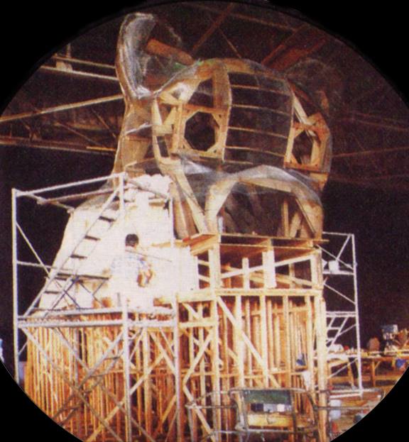
The story of Bulldog-related filming for The Rocketeer doesn’t end here, however. The scenes taking place inside the Bulldog’s attic head were not filmed in Ventura County, but rather at a second Bulldog set built at the Harbor Star Stage in San Pedro, Los Angeles. This set didn’t receive media coverage on the level of the Ventura County set, but information about its existence has survived, mainly via James Latta, who was the Harbor Star Stage manager at the time. Latta has described the Harbor Star set as featuring “the attic of the Bulldog Cafe for interior scenes and shots of the rear upper entrance.”27 The below certificate of authenticity for a Bulldog Cafe construction model used on the film, prepared by Latta, also mentions the second set.
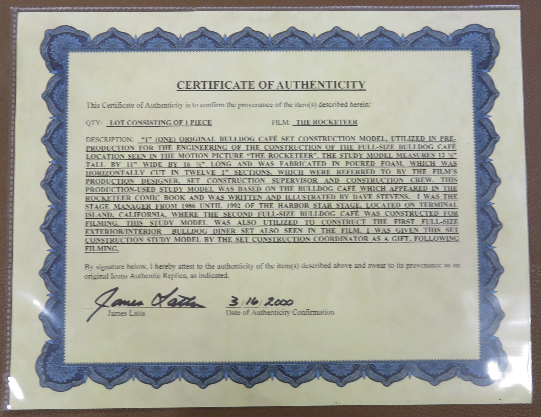
Source: The Rocketeer Club on Facebook.
The only photo I’ve found that’s probably of this second Bulldog set is below and shows it still under construction. Note that the Bulldog’s “body” is solid supports, without space for the dining room, suggesting that this is not just the Ventura County set. This photo was posted on Facebook in 2014 without any attribution. The circular outline around the photo suggests that it was published somewhere, but I haven’t been able to track that down.28 Because this set would have only been used for scenes taking place in the Bulldog’s attic, and shots of the back of the Bulldog’s head, I’m guessing that most of the Bulldog’s lower body remained unfinished.
Source: Facebook post, 2014.29
Around the time of The Rocketeer’s release in June 1991,30 31 the Bulldog Cafe set was added to the Backstage Studio Tour attraction at Disney-MGM Studios in Florida. Being a complete Bulldog and not just the upper portion, it was almost certainly the Ventura County set and not the Harbor Star one. The interior was removed, however.
The Bulldog was cut into pieces for the move from California to Florida. The scars from this modification can be seen slightly in some of the photos below.

The Bulldog Cafe set on the Backstage Studio Tour, 1991. Source: Retro WDW.

Another photo from 1991. Source: Joel on Flickr.

A view with the tour tram in the foreground from 1992. Source: Stack’s Liberty Ranch on Facebook.

Aerial photo of Disney-MGM studios, early- to mid-1990s. The Bulldog set is visible in the lower right. Source: Main Street Gazette.32

The Bulldog on a 1993 park map. Click for full image. Source: The Mouse Museum.
The Bulldog remained on the Studio Tour until 1996,30 when it was put backstage at Disney World and gradually succumbed to the elements. Below is an anecdote from a former Disney employee who saw the Bulldog in this state:
When I was working at WDW in 2002, it was behind the magic kingdom in an area they call PLUTOPark. … The cafe was in two pieces, lying side by side on the ground. There was a giant hole in one side of it.
Although it’s no longer present at Disney-MGM Studios (now called Disney’s Hollywood Studios), the fact that the Bulldog appeared in a Disney movie and theme park will probably be its greatest key to not being forgotten in the decades to come. Not only will Disney’s archival team preserve various Bulldog-related documents and ephemera, but fans of Disney movies, Disney parks, and of course The Rocketeer will always have a reason to remember it.
In 1994, the Petersen Automotive Museum opened in Los Angeles. On the museum’s ground floor was a replica Bulldog, displayed as part of the immersive “Streetscape” exhibit. As seen below, “smoke” occasionally rose from the Bulldog’s pipe.33

The Petersen Automotive Museum’s Bulldog replica under construction in 1994. Source: Hemmings.

The Petersen Bulldog, probably close to the museum’s opening in 1994. Source: Whipple Russell Architects (the museum’s original architects).34

The Petersen Bulldog in 2009. Source: Wikimedia Commons.
The Bulldog replica remained in the Petersen Automotive Museum for 20 years, labeled “The Dog Cafe” by a plaque. California Crazy was likely used as a reference for the name (and unfortunately, the incorrect “West Washington Boulevard” address and “1928” construction date).

The Petersen Bulldog’s plaque in 2011. Source: Joel on Flickr.
In 2014, the Petersen Automotive Museum was completely remodeled and the Streetscape exhibit was removed. In a happy development, the Bulldog replica was saved by preservationist Bobby Green of the 1933 Group.

The Petersen Bulldog undergoing disassembly in late 2014. Source: Hemmings.
The replica Bulldog was moved in pieces and reassembled on the back patio of the Idle Hour, an old Los Angeles bar shaped like a barrel that was in the process of being rejuvenated by the 1933 Group.

Moving the replica in pieces, late 2014. Source: Hemmings.

Reassembling the replica, early 2015. Source: @bobbygreendesign on Instagram.
To this day, the Bulldog sits on the Idle Hour’s back patio and can be rented out as a private dining room. Its pipe can still be seen to puff “smoke” on occasion.

The Bulldog’s new home behind the Idle Hour. Source: Infatuation.

The Bulldog’s interior (added after its move to the Idle Hour). Source: The Los Angeles Beat.

A masked Bulldog in 2020. Source: @idlehour on Instagram.
Sometimes I wonder if the reason the Bulldog was chosen to be part of the Petersen’s Streetscape exhibit in 1994 is because The Rocketeer movie had just featured it three years previously. If so, then we could trace a very clear thread from Alexander Wiederseder’s photo of the original Bulldog to Dave Stevens’ inclusion of it in The Rocketeer comic to its appearance in the movie to the replica at the Petersen and, now, the Idle Hour. That would be so cool.
I saw the Petersen Automotive Museum’s Bulldog replica many times while growing up in the Los Angeles suburbs. A few years ago, I found myself wondering what had happened to the replica after the museum was remodeled, which led me to articles about the 1933 Group and Idle Hour. Most of the articles also mentioned an address for the original Bulldog: “1153 West Washington Boulevard, Los Angeles.” Some of them also gave an approximate date range for the Bulldog starting in the 1930s.
I thought it would be fun to look at old aerial photos of that area and try to pick out the Bulldog, and started examining photos from the UCSB Map and Imagery Lab. To my surprise, however, 1930s aerial photography of West Washington Boulevard’s 1100 block didn’t look anything like the rural landscape seen in photos of the Bulldog. There were no open fields or spots where transmission towers could go.

West Washington Boulevard aerial photo, 1931. Source: UCSB Map and Imagery Lab, Flight C-1930, Frame 18.
A few Google searches quickly turned up the Bulldog photos from the Ralph D. Cornell collection (Photos 3 and 4) as well as the “Great Western Development Co.” video (Video 1). After a bit more searching, I learned that the popularized “1153 West Washington Boulevard, Los Angeles” address could be traced back the 1980 edition of California Crazy (with subsequent 2001 and 2018 editions repeating the same address). No sources mentioned the “638” address seen in the video.
Digging deeper, I learned that in the past, there had been two separate 1100 blocks of West Washington Boulevard in Los Angeles: the one in Pico-Union that still exists today; and one in Venice, on the section of West Washington Boulevard renamed Abbot Kinney Boulevard in 1990.35 I studied old Venice directories and aerial photos for a while to try and figure out if the address from California Crazy was really pointing there. The aerial photos looked just appropriate enough to keep me hopeful, but ultimately Venice proved to be a dead end.
At the same time, I was trying to glean information from the signage in Video 1. I searched the Los Angeles Public Library’s licensed Los Angeles Times ProQuest database many times for the phone number from the sign in the video (CA-8914). Once or twice I found the same number attached to a classified ad for property in the eastern Los Angeles region, but it never had any additional information about its owner. Finally, I searched for “CA-8914” on Newspapers.com instead of the ProQuest database (it turns out that Newspapers.com generally has more reliable OCR), and found the following advertisement from 1943 linking the Great Western Development Co., the phone number CA-8914, and a new address, 5207 Alhambra Avenue:

Source: Los Angeles Times, October 19, 1943, page A15.
I now had an address associated with the Great Western Development Co. seen in the video. It wasn’t a “638” address, but it was something. I then searched the Los Angeles Times database for “5207 Alhambra Ave” and found the “Firm Expands” news item from 1944, which laid everything out neatly. This gave me an address for the Bulldog: 638 E. Garvey Ave., Monterey Park. But this didn’t explain the “1153” seen in all the other photos, and it seemed unlikely for the odd and even sides of Garvey Avenue to have flipped at any point, even if its numbering scheme changed. Additionally, the stop sign next to the Bulldog in the video indicated that it was on a street corner, which didn’t match its surroundings in the photo. A vague theory I’d had that the Bulldog had been physically moved before the video was taken seemed more likely. One thing was for certain, though: it was a San Gabriel Valley building.
Emboldened by this finding, I did what I should have done upon first reading the caption to Photos 3 and 4 that mentioned “Valley Blvd., Alhambra,” and emailed the Alhambra Library asking for help. A research librarian there kindly sent me some photographs of restaurant listings from old Alhambra-area city directories from the 1930s. A breakthrough came with the 1937 directory, which as seen above had a listing for the Bulldog Inn at 1153 East Valley Boulevard. “1153” matched the address seen in most of the Bulldog photos and “Valley Boulevard” matched the Photos 3/4 caption. At this point, I considered the Bulldog mystery solved (but a few surprises remained).
Eventually, I was able to make contact with Jim Heimann himself and present my findings. He agreed that 1153 East Valley Boulevard was a better candidate for the Bulldog’s location than 1153 West Washington Boulevard, and told me the original address in California Crazy was based on a cafe called the “Dog” or “Bulldog” that had once been listed in old Los Angeles city directories at 1153 West Washington (specifically the Pico-Union address, not the Venice one). Interestingly, I never actually found this listing when looking at directories myself, but presumably it was out there somewhere in the pre-digital world.
After completing my intitial research into the Bulldog, I turned my attention to the Pup Cafe, which I’d learned about due to the two restaurants’ similar appearances. After doing some digging, I was amazed to find out that both restaurants were built by members of the same family!
With the Bulldog’s home in the San Gabriel Valley now looking less like a theory and more like a historical fact, I finally noticed one last, definitive piece of evidence for why it couldn’t have been located at 1153 West Washington Boulevard: that address would have had trolley tracks in front of it in the 1930s. Those tracks would have been visible in Photos 5 and 9.

The green line on West Washington Boulevard signifies a Los Angeles Railway (Yellow Car) trolley route. Source: David Rumsey Map Collection.

The red line on West Washington Boulevard again signifies a Los Angeles Railway (Yellow Car) trolley route. Source: Los Angeles Metro Library Archives.36
Below is a 1924 photo from the 1100 block of West Washington Boulevard37 of what those tracks looked like at ground level.

1156 West Washington Boulevard, 1924. Source: USC Digital Library.
The “1931” date for the Bulldog’s opening is based only on the fact that it first appeared in the 1931 Alhambra-area city directory. However, the directory itself was likely compiled during 1930 and published in late 1930 or early 1931. Actually, the latest the 1931 directory could have been published is February 1931, because the copy available on Ancestry.com has a “FEB 17 1931” date stamp on the copyright page. (To confirm that the stamp really said “1931” and not, for example, “1934”), I looked at the stamps in the 1930, 1932, and 1935 directories as well: each clearly matched the directory’s year.) All this is to say that the Bulldog could have also opened in 1930 or 1929. We know it probably didn’t open earlier than 1929 because “Joseph Andrew Maddox in LEMW’s Words” specifies that the Bulldog Cafe came after the Pup Cafe, which appeared in 1929. ↩
Alamy Stock Photo dates this photo to 1931, but it was dated to 1934 when printed in California Crazy: American Pop Architecture (2018). ↩
The full name of this city directory was Los Angeles Directory Co’s Alhambra (California) City Directory 1931 Including El Monte, Monterey Park, Rosemead, San Gabriel, Temple City and Wilmar. ↩
Besides looking at the mountains, we could also prove that the Bulldog was on the north side of Valley Boulevard by noting that its address is an odd number, then piecing together information about other businesses listed in old Rosemead directories until we’d confirmed which side of the street odd addresses went on. But looking at the mountains is easier. ↩
As provided, the collage caption is a little muddled: Note on back of photograph: [The Pup] Valley Blvd. Alhambra. [Bull Dog] Beverly Blvd. & Virgil St. L.A. [5-15-32]., Text from nitrate sleeve: Roadside Eating Places. The Pup – Beverly & Virgil [Bulldog] – Valley Blvd., Alhambra 5-15-32. The locations of the two restaurants seem to have been mixed up between the labeling of the collage and its sleeve. To clarify things, I verified that “The Pup” restaurant was indeed near the intersection of Beverly Boulevard and North Virgil Avenue in Los Angeles (I found a low-altitude aerial photo of it that I could match to old aerial photos of the entire neighborhood.) This leaves “Valley Blvd., Alhambra” as the intended label for the Bulldog. ↩
One thing I’m still not fully satisfied with is how the building marked “Lunch Stand” next to the Bulldog on this map doesn’t really appear in any photos of the Bulldog. My best theory is that at least for some time, food was sold out of the house to the right of the Bulldog as well, so it got labeled as another lunch stand on the land-use map. ↩
The “text, page 544” referred to in the photo’s caption reads: “Grotesque, indeed, are scores of startling, Coney Island-like buildings wherein food and drink are sold. Some are shaped and painted to represent giant owls, derby hats, shoes, airships, dogs, teakettles, windmills, mosques, wienerwursts, zeppelins, and igloos (see illustration, page 554). One cafe is built like a roundhouse, with a life-sized locomotive emerging from its front door. Another, the last word in realism, is a replica of a jail, bars and all!” ↩
For more information about Alexander Wiederseder, see the “Biographical Note” section on this page about Arizona State University’s Alexander Wiederseder photo collection. ↩
The full name of this city directory was Los Angeles Directory Co’s Alhambra (California) City Directory 1937 Including El Monte, Monterey Park, Rosemead, San Gabriel, Temple City and Wilmar. ↩
Some more trivia: Mr. Heimann told me in an email that this photo was actually taken by his own father’s cousin. ↩
For completists only: the visible text on the orange sign reads “…TERN DEVELOPMENT CO. / – REAL ESTATE – INSURANCE – CA 8914 / … ON RAMONA …ED RM … STUCCO …R TRANSP / 100 x 504 M3 ZONE $6000. CASH / GARVEY AVE 4 RM FRAME RM FOR STORE $8250.” Of note are the street names “Ramona” and “Garvey Ave;” both still exist in the Monterey Park area today (and of course the video was actually taken on Garvey Avenue). ↩
For a close-up of another old black-and-white stop sign in Monterey Park, see this link. ↩
See this link for a map of Los Angeles’s telephone exchanges in 1938, including “CApitol.” ↩
The Great Western Development Company is listed at 638 East Garvey Avenue, Monterey Park in the State of California Division of Real Estate Directory of Brokers and Salesman from 1943 to 1948, inclusive. Note that 1943 is earlier than the Los Angeles Times article describing the company’s move to Monterey Park. Presumably by the time the directory was published, the Great Western Development Company had already registered its change of address somewhere. ↩
For a long time I was approximating the Bulldog’s location with 8525 East Valley Boulevard, but reexamining the old aerial photo again recently, I decided that address was too far west and 8547 East Valley was closer. There was a good amount of space between the Bulldog and the Edison transmission tower right of way. ↩
This quote is also from the afterword of California Crazy: Roadside Vernacular Architecture (1980). ↩
I believe Chapter 4 of The Rocketeer (originally published in Pacific Presents #2 in 1983) marked the Bulldog’s earliest appearance in a comic book. Several collected editions of The Rocketeer I’ve looked at insert two pages at the very beginning of the story that take place at the Bulldog Cafe, so for a while I assumed that the Bulldog showed up in Chapter 1 of The Rocketeer when it was first published in 1982’s Starslayer #2. However, I finally looked at Starslayer #2 itself and those pages weren’t there; they must have been added in for one of the Rocketeer collected editions. ↩
Chapters of The Rocketeer were published across various independent comic books. Chapter 4 appeared in Pacific Comics’ Pacific Presents #2. ↩
“Flying a Rocky Road: ‘Rocketeer’ Rides a Bumpy Course From Comics to the Screen,” Los Angeles Times, June 16, 1991. ↩
The Rocketeer: The Complete Adventures, Dave Stevens, 2015, page 10. ↩
Here is the shot in question, from about 29 minutes into the movie. The scene’s editing implies that the Bulldog is to the right of the camera. ↩
There actually is an Encino Avenue-Oxnard Street intersection in the San Fernando Valley, suggesting that’s where the Bulldog was supposed to exist within the world of The Rocketeer. (Another clue that the movie was partially set there occurs about 20 minutes in, when Alan Arkin’s character, Peevy, says “That must have woke up the whole valley!”) Interestingly, based on the 1943 Renie Pocket Atlas of Los Angeles, this intersection didn’t actually exist in 1938, when The Rocketeer is set. (And although it exists today, there’s no 3500 block near there to explain the choice of the “3521” address). ↩
It’s pretty clear just from watching The Rocketeer that the interior and exterior of the Bulldog were filmed on the same set, but if that weren’t enough proof, Billy Campbell (who played title character Cliff Secord in the movie) confirmed on episode 29 of The Rocketeer Minute podcast (about 4 minutes in) that it was indeed an “indoor-outdoor set.” ↩
Jim LoGiudice was a crew member on The Rocketeer (source: IMDb). ↩
Latta’s public Facebook comments describing the Harbor Star Stage set are on the following two posts: here and here. The first post is the source of the “attic of the Bulldog Cafe” quote. ↩
Bing Reverse Image Search implied that the image appeared in this article on the Building Design magazine website. The article is behind a paywall so I haven’t been able to confirm this. However, I doubt that this article would be the first place the image was published. ↩
This post was public, but from someone’s individual profile (not a group), so I’m not going to link to it for privacy reasons. It didn’t offer any details about the source of the construction photo. ↩
According to an anonymous commenter at this link, the Bulldog was installed on the Backstage Studio Tour “in May or June of 1991 and removed in the summer of 1996.” ↩ ↩2
In this video of a Backstage Studio Tour from 1991 (at about the 8:30 mark), the tour guide points out the Bulldog Cafe and mentions that The Rocketeer isn’t out yet. So the set was present on the tour for at least a few weeks before The Rocketeer was released on June 21, 1991. ↩
This website originally uploaded the photo to the Internet, but it’s clearly not a personal photo and probably came from an old Disney publication, which I haven’t yet been able to identify. ↩
For a video of the smoke effect, see 3:57 into this video from the 1990s. (The whole thing is worth a watch if you’re a fan of the museum). One commenter on this Facebook post attested that he had worked on the smoke effect, achieving it with a “fog unit.” ↩
In 1994, Whipple Russell Architects were called The Russell Group (“Just the Museum for a City the Car Built,” Elaine Louie, The New York Times, June 19, 1994). ↩
“Part of Washington Blvd. to Be Renamed.” Nancy Hill-Holtzman, Los Angeles Times, February 25, 1990. ↩
This is a forgotten corner of the LA Metro website and may eventually disappear, but it’s all saved on the Internet Archive. ↩
Specifically, the photo is of the Pacific-Southwest Trust & Savings Bank, Washington and Burlington Branch (as described at the source). According to the 1925 Los Angeles city directory (page 2093), that bank was located at 1156 West Washington Boulevard. Brown’s Art Shop, visible on the left of the photo, is also listed in that directory (page 2075) at 1148 West Washington Boulevard. ↩