Cultural Analysis, Volume 9, 2010
The Shaping of a National Citizenry
Maps have long been part of the American cultural landscape. Plotting military advances and territorial expansion; regulating and demarcating land through surveys, thereby inextricably merging land and property, maps have shaped our sensibility of the landscape at the same time as they have guided our movement through it. The mapped identity of the U.S. as the visualized outline of the forty-eight contiguous states is, by now, a naturalized phenomenon both in the sense that it is taken for granted, and in the sense that the natural boundaries have been set by nature—originating at the Atlantic and terminating at the Pacific Ocean.3 The shape of the continental United States, established cartographically, unproblematically re-presented in road maps, railroad maps, atlases, school texts, advertisements, and news, has become iconographic. Inscribed onto the popular imagination, it has "entered the national collective image bank … [T]he shape of the United States is so ingrained in the minds of those who live here … that it stands for the nation as a symbol"(Holmes 1991, 7), which is then conflated with the continent—"America". In this nation/continent homology, however, nature operates metonymically with culture, and the cartographic presentation belies an ideological and historical shaping of the country that is anything but natural. In fact, the sleight of hand by which the "irrefutable" materiality of the ground that is presented and the scientific cartographic processes by which the in-itself-material map is produced transform the ideological possession of that land into its own reality and into claims that "we Americans" are here, coast-to-coast. This obscures alternative, often highly contested, mappings, and effaces the processes of coercion and consensus building which involve the interwoven strands of politics, economics, ideology, social change, power, and domination that have resulted in a singular narrative of national identity, visualized in the map of nation.
This notion of continental integrity fused with national identity is thus one of an imagined and contested space, in which neither the nation nor the space it occupies can be postulated a priori as preexisting or fixed, but is the outcome of specific historical, narrative processes. "America," thus, ontologically, is not an immutable, taken for granted "ground," but a potentiality to be filled with meaning and thus recognized as meaningful. Maps play a critical and yet largely unchallenged role in the ideological work of fixing such meaning. The apparent capacity of the map to hold together the nation from the internal and external forces of disintegration, the semiotic and rhetorical potency of the map, based, in part, on the deceptive fixity of the mapped terrain and the naturalness of the continental nation, can be seen as the imposition of a hegemonic view masquerading as "common knowledge." In other words, "it is the map that precedes the territory"(Baudrillard 1983, 2); "mappings do not represent geographies or ideas; rather they effect their actualization"(Corner 1999, 225).
In a sense, then, the maps of the continental United States show the development of an American [creation] myth which "… functions to control history, to shape it in text or image as an ordained sequence of events. The world is rendered pure in the process; complexity and contradiction give way to order, clarity, and direction. Myth, then, can be understood here as an abstract shelter restricting debate. But myth can also function as ideology—as an abstraction broadly defining the belief system of a particular group …" (Truettner 1991, 40). But these ideologies which undergird the overdetermined sense of order in any map are only possible through the continued discarding, forgetting, and evacuation of those strands that run counter to the main narrative; those counter mappings which threaten the integrity of the national space.
The narrative of "America," with hindsight as its perspective, presents a seamless and naturalized series of such myths—presumptions which subsume the Americas into a metageography which obfuscates its ideological underpinnings: the myth of continents; the myth of the nation state; and the myth of the East to West progression of civilization (Lewis and Wigen 1997, xiii), all of which have been mapped onto the terrain and the national consciousness. In this narrative, continents become fundamental building blocks of geography which are reified, acquiring the status of a "naturalized geographical taxonomy" (Lewis and Wigen 1997, 8-9). The idea of this continental America thus justified continental conquest in the name of national integrity, while the concept of a continental nation supported notions of American exceptionalism and privilege.
Although this dominant narrative seeks to organize the unified nation ideologically through the cartographic image of an imaginary America which is naturalized by the representation of a contiguous land mass, a reinvestigation of these maps reveals the sub-texts which constantly threaten to destabilize and challenge the singular narrative strand of American continental/national unity, as well as the historical changes that belie this mythic unity—the recuperative adjustments which seek to contain and subdue alternatives.
The Ties Bind the Nation
Although in the territorial uncertainties of the colonial period the map of America was shifting and contested, the general impulse of continental expansion was nonetheless dominated by an East-West logic (i.e., a N-S Frontier) until the Civil War. Here, again, the cartographic process inscribed the shatter belt of the astronomically surveyed Mason-Dixon Line, rupturing the East-West logic, threatening to expose the disorder in the apparent order of the map. As the United States reinvented itself as a unified, whole nation in the wake of the Civil War the West became even more central to the national mythos, and westward expansion and continental unification along the East-West axis resumed, marked, significantly, by the completion of the transcontinental railway in May of 1869, joining the Union and Central Pacific Lines.
The physical incorporation and linkage of the mythic landscape of the West to the rest of the nation provided the focus for American regeneration, reunification and self-affirmation. The marriage of mapping and the railroads served further to solidify the image of the unified, continental nation, sutured and reinforced by the iron rail grid. The story of these maps is one of masculine domination and conquest over Nature in the form of presidential acts rather than the story of those whose physical labor produced the railways, or who were displaced or dislocated as a result of them.
The railroads, as major landholders in the late nineteenth century, were to dominate the changing ways in which the nation was apprehended, not only through their linking of the continent, but through the hastening of the in-migration of settlers into more of the West, reconfiguring settlement patterns along the narrow corridors of railroad development. The American landscape was reduced to strips that criss-crossed the mapped surface, with vast, unknown, and emptied territories beyond, many of which had been stripped of their former significance.
The growing strength of the railroads and the increased demand for rail travel also ushered in a significant new presence into the landscape—tourism. Railroad tourism offered growing numbers of the elite a comfortable way to view and travel through the country. Tourism became typified as the act of viewing—sightseeing preselected natural wonders from the comfort of the Pullman car windows, or, at the very most, from the vista points provided by the luxury hotels that grew up at such destinations along the rail lines. Situated alongside or nearby the spectacular sights of Nature—the Grand Canyon, Yellowstone,4 and Yosemite—tourists were guided in an act of national communion and reaffirmation. As such, tourism initiated a new form of collective citizenship; the embodied retracing of a shared destiny, and a shared experience in the space of America.
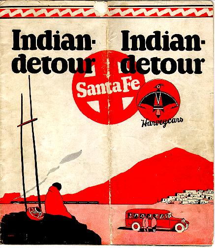
One of the earliest to reconfigure and repackage the landscape around the logic of the rail lines and the new viewing tourist was Fred Harvey, who famously repackaged the West as a series of motorcar "detours" that took city "dudes" to various vista points in luxury cars that conveniently detoured from the rail line into landscapes in which imaginary "natives" were colorful, silent, and static.5 [Fig. 1].
Fig. 1
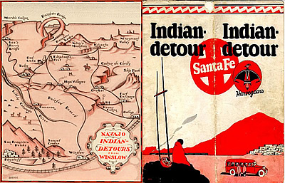
Harvey marketed itineraries as destination points on a map linked by the traces of roads and rail lines.
After the antagonistic and hostile natural and human forces in the West had been subdued, the tourist was able to romanticize and "experience" these forces in a repackaged state.6 These decontextualized and recontextualized tourist destinations, then, became imagined places, the precursors to contemporary theme parks, where reminders of suffering and social conflict are removed from the touristic purview. These touristic itineraries restaged narratives of conquest of the native peoples who were evacuated from the newly constituted national parks, put on reservations, and presented as ethnographic remnants of "authentic" Indian cultures in a decontextualized setting for the consumption of tourists seeking a palliative to the rigors of modern, urban life.
With the emergence of the vacation as an individual right, and the configuration of touristic sights as encapsulating the essence of the nation, tourism addressed and shaped a particular America and collective American identity. Tourism and nation building were conjoined—structuring the meanings of experience, desire, visuality, mobility, and consumerism; defining the "good life" as a social and moral imperative. Thus tourism, during this early period of railroad travel, allowed for an affirmation of the tourist's rightful place at the head of the social hierarchy and the American system. "In the spectacular vistas of the West, in a growing obsession with native peoples and their arts, Americans used a geographic place as mythical space … [t]ourism had become intrinsically linked to the formulation of the industrial age, to the combination of Manifest Destiny, empirical knowledge, and romantic thinking that typified the fin de siècle" (Rothman 1998, 49).
Promotional Maps and Tour Itineraries
Nation, conquest, private enterprise, industrial expansion, a new consuming tourist class, and a radically different conceptualization and organization of time and space focusing on an imaginary national landscape were merged and distilled in the emergent new phenomenon of promotional cartography. Technological innovations such as the wax engraving process and the use of pulp paper, along with mechanized, industrialized production, resulted in the increased availability of cheap road maps for an increasingly mobile public.7 The cartographically defined vision of the nation was thus tied to the commercial interests of the railroads and tourism, and as such was abstracted and delimited according to financial imperatives. Despite the claims to cartographic accuracy and comprehensiveness, these maps reveal the competitive motivation of advertising campaigns.
Fig. 2
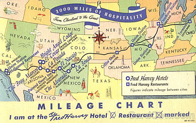
Mapping Destination. The U.S. visualized as a series of stops8
Railroad maps, like the form of travel they purport to represent, also emphasize destination. Thus the type of information contained in the maps, the emphasis on sites along the routes at the expense of a broader, detailed relationship with the landscape, guided the consuming public in ways of seeing that would in turn affect the vision of the nation. The railroad map, tracing and anticipating the tourist's itinerary, both facilitated and limited the individual's movement. [Fig. 2] Space became known through a process of miniaturization at the same time that the individual was positioned in a common social space. The map, then, like the book, could become a "talisman to the body, and an emblem of the self"(Stewart, Susan 1993, 41) through which the reinscription of personal itineraries onto routes proffered by the printed map effected the reinvention of the map which could then be displayed, revisited and re-presented.
Blazing Trails
The railroads dominated American transportation and travel in the second half of the nineteenth century and the beginning of the twentieth century, and during this period railroad maps continued to inform the American continental imaginary. Gradually, however, road maps began to have a presence. Initially, these maps and the associated "Good Roads Movement," were local and discrete in nature, catering to cyclists. In 1908, as the first production-line Model T Ford appeared, systems of travel, touring and mapping in the U.S. began to change. Henry Ford's revolution transformed the ways in which Americans lived forever, and did so rapidly: in 1900 there were eight thousand cars registered; in 1910, one million; by 1915, at the onset of WWI, two million (Yagoda 1998, 35); by 1920, eight million; and by 1930, twenty-three million (Rothman 1988, 146). But Fordism's effects went deeper: in his assembly-line worker, in the homogeneity and standardization of his product, and in the assurance of a decent wage, Ford initiated a consumerist regime of demand-driven economics, and created a middle-income class with money to spend and leisure time in which to recreate. This Fordist revolution initiated a change in individuals' attitudes toward the land—at once more distanced (in terms of labor and production) and more intimate (in terms of car travel and the individualized travel through space). Early car travel upset the "hegemony of the intellectual message encoded in railroad travel" (Rothman 1988, 144) by putting the car owner in the "driver's seat" to deal with the many unexpected contingencies of road travel. This was the "democratization" and appeal to the sense of individualism and adventure that early car travel offered middle-class Americans.
As car travel eclipsed train travel so was the nature of travel transformed; an elite, highly-structured cultural tourism was replaced by a more personal type of experience-based recreational tourism. In the transformation, tourism focused less on destination and more on the experience of the road, and yet destination and experience still existed within the same nationalistic symbolic rhetoric: the grand national parks of the West still stood for America's might; the historical parks of the East reframed the war of independence and celebrated the birth and glory of the new nation; while the ethnographic displays of Indians in museums and at arts and crafts shops all reinscribed a particular social order and the privilege of the tourist class. All of these assumptions operated on the by-now invisible background of the continental United States, and all were narratives that naturalized conquest—the tourism of hegemony.
As more cars and more drivers with vacation time and the desire to exercise their freedom and independence began to hit the road, they were met by the newly established Highway Associations of local businesses and commercial enterprises ready to capitalize on this new market. These early associations established the "Blazed Trails Program"—the first system of marked and mapped regional routes. Routes with evocative, rugged names benefitted travelers' own images and expectations—The Black Horse Trail; Dixie Highway; Erie Trail; Yellowstone Trail. Probably the most famous of these was the Lincoln Highway, which traced a line from New York to San Francisco.9 In 1916 it was estimated that five to ten thousand motorists made the entire transcontinental journey across the Lincoln Highway (Joy 1917), which was mapped by Rand McNally in 1913 using previous continental railroad maps as a template. Thus, although car travel effected a democratization of tourism in contrast to the more exclusive earlier rail tourism, the accompanying road maps which interpellated an even larger portion of the citizenry into the discipline of the nation did so according to a pre-existing grid.
The map referred as much to an imaginary terrain as to any "real ground," and the mapping of the continental road systems, like those of the railroads earlier, was often prior to the actual presence of the roads. In Emily Post's diary of her transcontinental road trip across the Lincoln Highway, her companion's comments bear witness to this: "It's an imaginary line like the equator … [o]nce you get beyond the Mississippi the roads are trails of mud and sand … [t]hese are not towns; they are only names on a map"(Post 1925, 7; cited in Akerman 1993, 79). That people planned their itineraries based on these lines on a map is a testament to the power of the map to effect its own reality, naturalizing an imaginary landscape.
Constructing National Unity
Increased demands for long-distance travel and transportation required new types of road construction, and in 1916 the Federal Aid Road Act appropriated $75 million to the standardization not only of road construction, but of road designation (Weingroff 1996a). Hampered by the demands of WWI, highway construction stalled until the passage of the Federal Highway Act of 1921, ushering in the heyday construction period of the 1920s (Weingroff 1996b). After WWI, highway construction, mapping and signing continued, and the standardized federal highway numbering system, initiated in 1926, signaled the demise of the older, more regional Blazed Trail system. It was during this period that the road map and road travel began to truly shape a unified national consciousness:
The creation of the national highway system in the United States was guided by the hope that it would eliminate the last natural barriers to national integration. And thus early auto road maps were relied upon to conquer the vast American space, to invite transcontinental travel by car. American auto touring ever since has had less to do with travelling in the country than through it. The bold-line, sparsely detailed aesthetic of American road maps reflects this detachment from the countryside. (Akerman 1993, 79)
These road maps, stripped down to the essentials of the road trip's demand for movement, showed only what was appropriate for road travel, and this minimalist presentation and limited topographical relief effected a distantiation from the landscape, opening up the map space which could then be "filled in" with sights, tourist destinations, and imaginary places projected onto the surface of the map. As these sights became the destination, they also portrayed the road trip as an "experience," and thus the reproduction of these sights—the post cards, photos, souvenirs—not only made the sight "real," but also validated, materialized, and commemorated the experience into the future.
During the Depression and the subsequent New Deal Era, the federal government became even more involved in the work of cultural production, shaping the American citizenry in accordance with the unifying goals of Progressivism. As part of the WPA, in 1935 the Federal Writers' Project was allotted $6,288,000 and employed sixty-five hundred writers to produce the American Guide Series, a collection of over 400 volumes of "regional guide books"(Bold 1999, xiv).10 These writers, although guided by certain preconceptions about what constituted points of regional and local interests, were also managed and incorporated into the overall agenda of the national agency. The central office in Washington ultimately arbitrated local variation in order to map out a uniform and unified America onto a retraceable grid. The guidebooks' promise, beyond a make-work project, was pedagogical: teaching the American public how to not only read the newly remapped and re-presented landscape, but how to be in it. Road travel became insistently work, national duty, as well as play. In this, the guidebooks were informed by not only the dictates of the WPA, but also a cluster of agencies that included the National Park Service, the Department of the Interior, and also state, and local agencies, which, through "preservation, education, and display … were closely tied, by production and rhetoric, to the New Deal's vision of the United States as a nation of communities"(Kammen 1991, 299-527; quoted in Bold 1999, 4). Guidebooks also had widespread distribution; standardizing and normalizing the vision of American unity:
Volumes in the American Guide Series were distributed to public schools, to refugee centers, and to the libraries of military bases, as well as being prominently exhibited in bookshops, department stores, hotels, transportation depots, and advertisements throughout the subway system. By mid-1936, 431 radio stations were using Works Progress Administration radio material. (Bold 1999, 12)
The widespread dissemination of the message of the guides,11 as well as the "documentary style" they assumed, served to naturalize not only a particular text of American-ness and the natural order of existing social relations,12 but also served to naturalize the ritualistic act of traveling along a prescribed route through this American landscape. In contrast to the dislocation and displacement of the Depression, the New Deal and the guidebooks in particular stressed "purposeful movement" that was destination oriented—to see the sights, to relive history, and to know one's country.13 The guides, issued at a particular moment in American cultural history just before the onset of mass tourism, served as the texts of the rhetorics of nationalism, and their structure and presentation of the landscape of America, the sights and points of touristic consumption, were to set the template for tourist guides to come14 which would replicate the form as well as the power relations that inhered in the assumptions implicit in the guides' presentations.
Not until the challenges to the narrative of national unity and harmony in the 1960s did the model set by the guides suffer. But, as with all cultural production, once the genie is out of the bottle, the control of meaning and dissemination is imperfect. Those images and descriptions of the guides of the 1930s, unmoored from their original context and social signifiers, float freely in a complex set of cultural scenarios and imaginary landscapes, becoming the sites of nostalgic reappropriation and reconfiguration, as well as objects which, through consumption, possession, and ownership, reinsert the tourist into an entirely new imaginary landscape.
The Road Trip
Geography became political destiny and personal fantasy in the post-WWII family vacation—the road trip. The road trip fully emerged in the post-WWII era in a perfect convergence of social, economic, and political factors, becoming the iconic encapsulation of the "good life" and the "American Dream." Americans were ready, after the austerity of the war effort, for movement and consumerism, and the post-war economic boom provided the capital incentive. Car ownership was climbing: in 1948, fifty-four percent of families owned cars; by 1960 this was seventy-seven percent (Rugh 2008, 18). There were nine car manufacturing companies, unable to keep up with orders, and generally, the demand for all petroleum products, after war time rationing, rose eighty percent between 1945 and 1957 (Jakle and Schulle 1994, 67). And cars got bigger. This was the era of the station wagon, big enough to accommodate the growing Baby Boom generation. Car manufacturers, and the expanding ad industry that accompanied them, not only spoke to this growing market, but, through the advertising images displayed in magazines and on television (itself a rapidly expanding post-war socializing experience), tended to normalize the very family it was appealing to: a 1954 magazine ad for the Ford Ranch Wagon proclaims, "There's always room for one more, in a FORD Ranch Wagon!"(Rugh 2008, 22).
Cars were one part of the equation; freeways were another. In 1956 the Federal-Aid Highway Act was signed, allocating federal funds for the construction of an interstate freeway system, argued, by then-President Eisenhower to be necessary for national security. The consequences of the introduction of the freeways, however, are much more profound and long-lasting. Freeways effected a completely different way of being in space: they facilitated the rise of the suburbs by making commutes fast and without stops, and thus inevitably longer; they standardized road travel, incorporating freeway design into the national model; they distanced the driver and passengers from the surrounding countryside, thus defining any car trip by the points of departure and destination; and they institutionalized the association of being American and being "on the road," since freeways by definition were not local, and tended to decentralize and segregate zones of activity, and did so, primarily, to the exclusion of other modes of transportation. Clustering around the infrequent turnoffs were new subsidiary industries: gas stations, fast food chains, strip malls, and motels, all positioned to facilitate travel along the freeway, but also to be within the view of the motorists from the road, and all of these industries became increasingly standardized across the entire system. These tended to change the ways in which Americans in the post-war era configured their work and leisure times to be in conformance with the logic of the freeway—minimizing deviation, eroding the possibility of a different, "uncharted" excursion. The speed of travel that the new freeways enabled opened up the potential for the cross-country family road trip, enhanced by the comfort and familiarity of standardized fast food, uniformed gas station attendants, and motels that, like Howard Johnson's, offered rooms in which "kids stay free," and whose motel pool offered "roadside entertainment" included in the night's price.
The 1950s thematized nuclear family was the embodiment, enactment and justification for the "Cold War consensus"(Stephens 1999; Conrad 1999a, 324-328), linking political policy and "family values" as it merged domestic and national containment. "The Cold War era generation, in the wake of the disruption of World War II and the uncertainty of the new, nuclear age, looked "homeward" to the isolated, stable, sexually charged safe haven of the home and family"(Conrad 1999b, 145). Families were "re-domesticating" and suburbanizing "in the intersecting currents of Cold War ideology; the domestic, family romance; consumerism; and the rapid technologizing of mass media"(Ibid). The "family vacation," in this context, became the model of family togetherness: "Taking a family vacation was justified by adherence to the ideal of family togetherness, out of a belief that a vacation would strengthen family bonds"(Rugh 2008, 12) and thus, by extension, the strength of the nation. The newly emerging concept of the "family vacation" was an aspect of the processes that this age of high industrialism and wealth intensified—processes which included massive social reorganization, lifestyle changes and expectations, increased scheduled leisure time, the rise of consumerism, and the valorization of the nuclear, domestic sphere. [Fig. 3] Thus the nuclear family, recreating in the vacation landscape, linked family life to the car-centered, freeway-accessed lifestyle, and also to larger political discourses of nationhood.15
Fig. 3
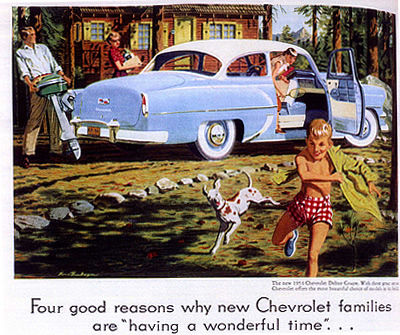
Family values, consumerism, and the Road Trip Family Vacation, circa 1954
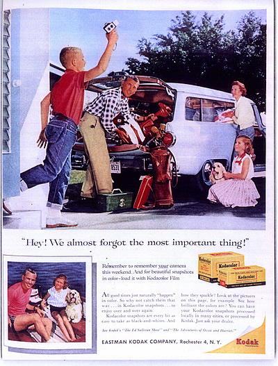
The family vacation on the road became a moral and national (security) imperative, and the nuclear family, inwardly focused, was ideally suited to perform one of the most important national duties—consumption. Through the insistent and redundant mediated images of the 1950s American families were instructed how to be and how to have fun. Television sitcoms, ads for theme parks, for Kodak film and Cameras, ads for cars and gas all interwove their primary message with that of the normalizing message of the family that is strengthened by togetherness—and that togetherness was most effectively and emphatically enacted on the family vacation. [Fig. 4]
Fig. 4
Documenting and Commemorating the Family Road Trip16
The model of the nuclear family was bifurcated along spatial, temporal, and gender lines into the feminized home sphere and the masculinized work arena away from the home. During the two-week vacation, these spatial, temporal, and gender relations were temporarily reorganized around a masculinist imperative, when the father reinserted himself into the day-to-day sphere, albeit "on the road." The vacation was determined by the father's work schedule, and leisure time was scheduled, regularized, and rationalized in a process made manifest in the road trip itinerary and road map. That the road trip was under the stewardship of the father is explicitly illustrated in road maps and other gas station promotional material in which station attendants seemed to be speaking directly to a male driver/consumer—the head of the household who maintains control "at the wheel." At the same time, the domestic sphere was maintained on the road, particularly with the rise of the motel, complete with kitchenette. Vacations thus served to reaffirm the familial, and by analogy national, order and hierarchies. Additionally, through the road trip, retraced across the regulating and unifying grid of the national highway system, each individual and family was interpellated into the physical and symbolic national landscape which was interpreted and presented for consumption in the standardized road map and the tour guide. And while the family vacation was directed out into the touristic landscape of the nation, the family, traveling in its "home away from home" was increasingly insular, with leisure and recreating linked to asocial consumerism.
In the geography of the imagination the road trip epitomized the unfettered freedom of the open road, with the driver as the master of his own destiny, and thus fulfilled the escapist fantasies of rugged individualism and personal autonomy.17 The road trip was a compact and elegant metaphor for the "American Dream" of democratic opportunity and individualism (Patton 1986, 9). The escapist realm of the road trip, enabled by mechanized labor and mechanical reproduction, was apprehended as a "break" from the routine of the work-day world,18 a move from creation to recreation. The road trip exemplified and shaped a particularly American collective identity, mapping a system of meaning onto the landscape and its citizenry, and structuring the meanings of experience, desire, visuality, mobility, and consumerism by which the "good life" was defined as a social and moral imperative.19
The intertextual representations of/on the Road enabled the enactment of fantasies of power, individuality, autonomy, and freedom onto pre-imagined landscapes as part of the mapping of an American identity. The road trip, as cultural practice, ritualized personal engagement with a reconfigured and managed landscape as it shaped identity. The mapped, organized, and pre-scripted landscape naturalized its own construction as it naturalized our passage through it. We were invited to "Discover America!"20 —the act of "discovery" masking the artificiality of reconfigured landscapes, presenting them as inevitable. Furthermore, in the touristic consumption of and (re)enactment through these imaginary landscapes, individual family stories are woven back into the national: scripted landscapes of desire which are reinscribed, and memorialized in the snapshot memory. Landscape thus, as W.J.T. Mitchell reminds us, "…circulates as a medium of exchange, a site of visual appropriation, a focus for the formation of identity"(Mitchell 1994, 2).
As highways became more ubiquitous and standardized, car travel faster, maps more abstract, and the tourist itinerary more insistent, the contingency/adventure of the open road and the appeal to individualism remained only in the imagination. In fact, the roads and the prepackaged destinations and sights that the road map/tour guide promised came to homogenize the experience into an increasingly predictable series of themed environments, in which fast food chains, gas stations, chain stores, and motels often merged into one giant roadside site. This disjuncture between the lived and the represented—this text of nostalgia and longing—allowed for the collective re-membering of a non-existent place, the fertile ground of identity formation and maintenance. These sites of longing were necessarily experienced as sites of compensatory consumption, increasingly experienced through the road-side attractions in what Mark Gottdiener has called the "theming of America" and Umberto Eco has referred to as "hyper-reality"—locality as simulacrum (Conrad 2004, 181), realized fully in theme parks, which achieved their quintessential expression in Disneyland and Disneyworld.
Know Your Country! Wider Horizons Makes Better Citizens
Fig. 5
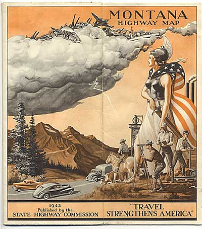
"Travel Strengthens America"
The narrativization and the representation of the national landscape, directed specifically towards this new type of car touring in which tourism and nationalism combined to dictate ways of seeing and ways of being in the land, were embedded in the road map. Knowing one's country, touring those sites accessible from the road and highlighted on the map and in the tour guide, became a personal reenactment of the narratives of America's destiny and thus a patriotic duty. This duty was fulfilled by the ritualistic, embodied interiorization and personalization of the nation through its surrogate, the map of the nation. Maps provided the totalizing national space into which diversity was subsumed. Through the retracing of the specified routes, the road trip was the enactment of this unifying principle, showcasing the local/regional/ethnic as commodity, standardizing the roadside experience (never far from the interstate), enjoining all in the same endeavor: "Know your Country!" But this knowledge (and movement) was doubly prescribed; onto the road that cuts through the land and onto the trace of the road on the map. Using the map thus became a disciplinary, rationalizing exercise, in which we were directed to consume the landscape and the products of tourism (evidence of our journey), and were incorporated into the larger national premise—consumerism, masquerading as re-creation. The road trip was not only a way to facilitate and affirm one's personal and family autonomy, it was a way to do so within the context of a larger national destiny. Promotional road maps thus replicated preexisting master narratives of progress, mobility, independence, and destiny. [Fig. 5] 21 In following the trails inscribed and illustrated in these maps, tourists could retrace and reenact the nation's history: [Fig. 6], ritually and corporeally experiencing the national narrative.
Fig. 6
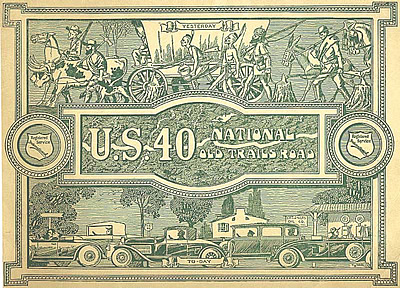
Retracing a Generalized History - U.S. 40 National Old Trails Road, Registered Service International, 1924. Osher Map Collection. Note how the "historical" trace conflates and rewrites the generalized narrative of Westward Movement.
Touring American was an act of consumption that partook in the markers of America's might—industry, monuments to government and democracy, as well as natural wonders which were metonymically and metaphorically linked to political and military might. Road maps also frequently retraced the steps of pioneers,22 encouraged the development of a national mythology surrounding the "Fathers" of the nation,23 and established battle sites as pilgrimage destinations in a sacralizing of the secular.24 These imaginaries of freedom, independence, and the lure of the open road, however, were overlain onto imaginaries of conquest,25 dominance, and violence.26 Thus the homogenizing experience of the pre-charted road trip existed within a much larger system of signification and spoke to a particular vision of America and a limited version of its history, one in which many actors were erased, making the touristic participation in "American" history essentially a foreign experience for many who were nonetheless exposed to the commercial images.
As the narrative of nation excluded a multiplicity of versions and voices, so too the presumed consumers of the road trip, the audience to whom the road trip imaging was most obviously directed, was that middle-class, white, heteronormative, suburban family with the father at the helm; that social realm which most perfectly reflected the imagined nation, and to which all were encouraged, especially through the commercial media, to aspire.27
Diversity was subsumed under unity in this narrative and rendered peripheral to the experience of the road trip itself, in the form of silent and invisible workers whose labor made the touristic experience possible [Fig. 7], and also in the imagery of postcards, souvenirs, and maps in which racialized others have become part of the roadside attractions associated with touristic consumption [Fig. 8].28
Fig. 7
Scrap-book post card of a road-trip Motel. http://www.thepostcard.com/cs-scan/6700/6706.jpg. Available for purchase for $4.50; decontextualized nostalgic "Americana."
Fig. 8
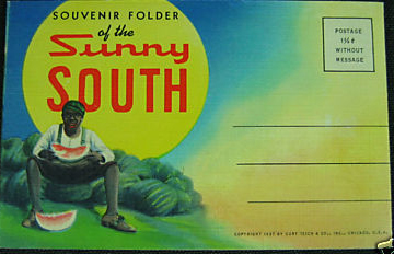
Vintage SUNNY SOUTH
Souvenir from 1937, on sale on Ebay 1/09.
Touring Race: Recreating in the Playground of the Imagination
The systems of signification that constitute and represent the bourgeois American subject continue to reinforce entrenched ideologies of race, naturalizing racial hierarchies and oppression in their ubiquity and "ordinariness." But the racialized "other" is not only the subject of this oppression, it is fundamental to and constitutive of a naturalized, normalizing American-ness. Writing specifically about representations of African Americans in literature, Toni Morrison has described notions of "American-ness" as responses to a "dark, abiding, signing Africanist presence" (Morrison 1993, 5), which has enabled the constitution of the new white male as the site of American privilege and power. This racialized presence also played a role in the mapping of American-ness, through the production, consumption, and reproduction of pictorial road maps and other tourist ephemera related to road travel, as well as through the systems of racialized imagery to which these are intertextually related and from which they derive meaning. Road maps in the mid-20th century, in their ubiquity and in the fact that they were given away free were certainly "ordinary"29 and unremarkable. The mundane aspect of the road map, however, obscures the political labor of collective memory which necessitates the forgetting, evacuation, and reconfiguration of the past, reinforcing and reinscribing a highly racialized presentation of "America." These images, inserted into these ordinary maps, themselves become less remarkable and more firmly interwoven into the fabric of dominant American culture, and serve to circulate ideologies of race in and through such commonplaces.
Pictorial maps are a particular genre, the superposition of images onto the road map, a conflation of the "scientific" and the "playful" that produces an integrated text of Americanness with deep ideological foundations which are reproduced without drawing attention to themselves, hidden in the "ordinariness" of the roadmap. The genre of the promotional pictorial road map reached its peak during the 1930s and 1940s, continued in popularity and distribution during the "golden age" of the road trip—the post WWII era—and gradually fell out of use along with the free road map as the road trip was supplanted by other forms of travel and tourism. Pictorial maps were usually on the back side of more conventional road maps, and signified a modulation from the public to the private, from macrocosm to microcosm, and represented both commodity and knowledge, fact and fiction (Stewart, Susan 1993, 41). The exaggerated, fictive and playful nature of the pictorial road map with its childlike and infantilizing illustrations, lack of detail, and inattention to scale contrasts sharply with the claims of objectivity and accuracy implicit in the stark, surveyed road map on the reverse side. The standard road map's emphasis on the lines inscribed by the traces of the roads themselves, in contrast to pictorial maps in which roads merely locate the place of images, serves to resolve the tension between the linear teleology of "passage," with the stasis and idiosyncrasy of "place".
Although there are hundreds of pictorial maps in existence, generated primarily by oil companies as free promotional gimmicks until the 1960s,30 most used and reused extant imagery that constituted a "common sense" set of attitudes towards race relations. This makes a specific historical reading of these images more difficult, as they are reproduced over a period of several decades, decoupling them from any claims to context, and pointing to a metaphysics of racism as well as the semiotic potency of all such racialized imagery.
Replicating the western progress of civilization—settlement, railroads, and finally interstate highways—American national maps are to be read East to West. Pictorial maps of New England and the Eastern Seaboard read as centers of civilization, and history is represented by markers of progress—buildings, bridges, sites of historic battles—and emptied of human figures. The reader's eye is then directed West and South, reenacting the narrative of Manifest Destiny. The South is the province of raw material and raw labor, epitomized by the Black field worker.31 The Southwest is an ethnographic encounter of another sort with a dehistoricized relic from a nonexistent past—the "native" in full regalia.32 The Far West is the land of spectacular nature, awesome greatness and power that could be used in analogy to that of the nation itself.
Fig. 9
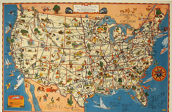
A Good-natured Map of the U.S.—Greyhound Lines, 1938
A close reading of one such pictorial map [Fig 9]—"A good-natured map of the United States setting forth the services of The Greyhound lines and a few principal connecting bus lines,"33 serves to illustrate: The offhand manner in which the imagery is presented as just "good-natured" distracts attention from the intertwined discourses of the nation, tourism, and commerce, which ultimately give meaning to the map's surface. An investigation into the specific images on the map [Fig 10] reveals a highly complex system of racialized social hierarchies encoded in the presented or absented bodies, and reveals a process by which the racialized other is available and exposed to the presumed subject's view, while the subject remains invisible.
Fig. 10
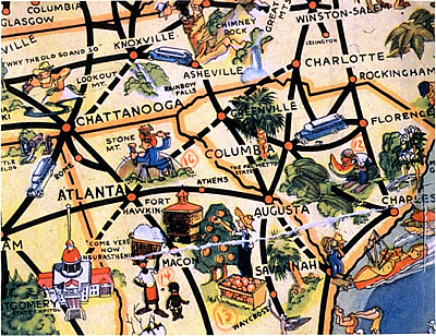
"Good-Natured" Images of the "South" include:
An Alligator chasing a black man up a palm tree—South Florida
Black mother and pickaninnie in cotton fields picking cotton—Georgia
Boy in a watermelon Patch—South Carolina
Black Boy holding up a possum, "Jes dinnah, das all"—Alabama
Black cotton pickers, man and wife, "Honey, we sho is pickin lots of cotton"—Texas
Texan Law man, with a 10-gallon hat and handle-bar moustache, "Thar's room in Texas for all of Yurrup and half of Africa, yes suh,"
Police man and other man with gun near Memphis—"Crossroads of the South"
In the South, illustrations carrying racial significance operate within an intertextual semiotic sphere in which these maps, tour guides, postcards, as well as non-tourism-related images all relate to a general semiotics of "blackness"—infantilized, backwards, bestial, consumed by sexual and gustatory urges, criminal, and marked by speech that is "inferior"—a marker of backwardness, but also an exclusion, a devoicing. These images of the South were ubiquitous, and as most of the production of printed images in the form of maps and postcards originated in the North, specifically Chicago, coincident with the migration of Blacks into that city, it can perhaps be suggested that the emphasis on rural Blacks in the South not only points to a desire for the "good old days of the happy plantation darkie" rather than the urban racial tensions in daily life (note the absence of any human presence in Chicago on the map), but also a distancing, a quarantining and segregation of Blacks in their "proper place."
The infantilized, brightly-colored, stereotypic, cartoon-like figures of Native Americans, African-Americans, and Mexican-Americans masquerades as a cultural diversity of sorts, effacing the violence behind these images. The "casual innocence" of the Greyhound map can't fully mask the terror implicit in the image of the Black boy eating watermelon in a patch near Augusta, the barefoot Black woman and her diapered baby picking cotton near Macon, or the Plains Indians in full regalia alongside their teepees in Montana, ironically placed close to a cartoon depiction of the Battle of Little Big Horn. These pictorial maps attest to and distract the viewer from the "evacuated presence" of racist subjugation, dismemberment, annihilation and premature death that constitutes the larger non-White experience, and, it could be argued, the reproduction and repeated consumption of these images metaphorically continues this process. To continue to reproduce such images "innocently," to protest that they are "just tourism" suggests the possibility of "memory without consequences"(Lippard 1999, 119). In fact, it represents an erasure of memory, a collective amnesia, which obscures a "life-and-death struggle between memory, denial and repression"(Ibid) in which the invisible operations of power maintain an entrenched network of privilege and domination.
Consuming Citizenship
Road maps, with their standardized and authorized routes, are regulatory; travel is delimited, prescribed by the route. Pictorial road maps, the superposition of images onto this grid, contextualize those routes; informing, shaping, instructing and pre-interpreting our movement across the mapped landscape. Along with the use of road maps to plan, trace, and plot travel itineraries however, tourists of this age of road travel also engaged in a series of memorializing projects [Fig. 11]—souvenir and memento collection, photography, and scrapbook production. In these individualizing acts, American subject-hood was constituted in the incorporation of images and "personal" experiences into commemorative, narrativized scrapbook projects that use the road itinerary as a template. Generic post cards become personal proof of passage when collected in a trip's scrapbook, while the national is transformed into the personal through the process of miniaturization.
Fig. 11
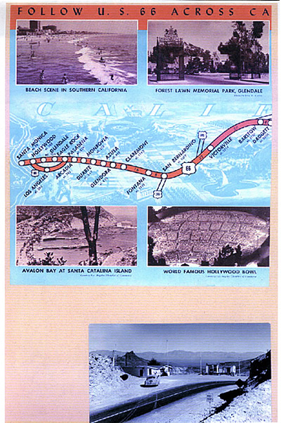
Post card of Route 66 and points of interest in California.
From a Scrapbook in the Newberry Library collection.
Scrapbooks speak to the labor of leisure—the labor of cultural (re)production. Leisure is thus in the process of becoming commoditized, becoming work in its own right. The act of scrapbook making, the cultural production of family, nation, and middle America, was the "work" of the feminized sphere; women and children who were thus interpellated into the larger consumerist regime, and into the ideological regimes at work in the representations that were recontextualized in their own "personal" scrapbooks. Ironically, the memorialization of this vacation time was also an act of mechanical reproduction along regularized, scripted lines. The use of photographs and postcards, and the organization of these into a linear, chronological progression often mirrored the route inscribed by the highways and interstates, and in fact, maps were often included in trip/vacation scrapbooks of this era [Fig 11].34
Fig. 12
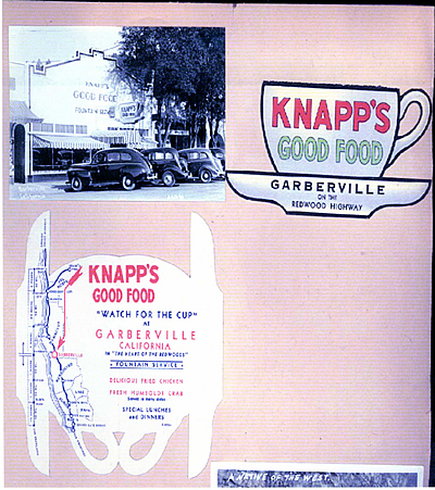
Page from Scrapbook with menu memorabilia, themselves located on a map.35
Personal photographs do not usually find their way into travel scrapbooks. Instead, they are filled with postcards, purchased photographs, pictures from road maps, brochures, promotional material from various sights, and mementos, such as napkins, place mats, menus, etc. [Fig 12]. The rejection of personal photographs and the inclusion of textual material directly from the postcards and brochures is an attempt to authenticate the experience: "I was there —," while simultaneously claiming the authority of the "experts"—converting the scrapbook into a testimony of the "more real than real."
Travel scrapbooks, linked to pictorial maps and tour guides by their shared images, can provide insight into the reception, incorporation, recapitulation, and sometimes recontextualization of ideologies at the individual level, suggesting, again, the diffuse operations of power. The scrapbook is a prosthesis, the function of which is to generate an external interiorized space—an exteriorized subjectivity. The bourgeois subject can create and revisit his/her own creation of self, consuming a recontextualized and repackaged narrative of both travel and longing, and in this way, the images become reinserted into narratives of longing and desire as well as of order and authority.
In comparing the images on maps and other mass produced items with those used in scrapbooks made by individuals, some emerged more frequently and emphatically than others, and these suggest the intertextual field of meanings that accrue to these images, enhancing their potency, and also points to the rhetorical moves that insistently effect the persistence of ideologies as "commonplaces." The imagery of everyday life—that found on promotional road maps, postcards, matchbooks, food, restaurants—in its ubiquity, attests to and distracts the viewer from the evacuated presence of racist subjugation which constitutes the larger non-white experience, and, in fact, the reproduction of these images is part of this, reinscribing the possessive investment in Whiteness (Lipsitz 1995). The fact that many of these images—often described as "adorable" and "wonderful"—circulate today on eBay and among post card and map dealers seriously undermines any denial that a major subtext to the American narrative is that of racism.36 These images now circulate freely, untethered to their original context. Now the signifiers of race have been decoupled from the signified, from any context other than that of racism itself, and operate metaphorically, disinvested of consequence. This resonates with the larger argument of this article that ordinary "commonplaces" are replicated in physical throw-away commodities that reinscribe disposable images of caricatured people inhabiting an abstracted place, while these maps of abstracted space facilitate our journeys into our vacation selves where we "dream of escape" while, at the same time enact the "simple life" of relaxation.
America Mapped
We live in a cartographically realized and informed world. This is not to say that maps were not discursive battlegrounds in pre-modern times,37 but they are now ubiquitous, everyday, their rectilinear logic enacted with each venture into the street. We use Mapquest and GPS guidance systems, deferring to and depending on the imposed logic of the grid. But maps tenaciously assert an empirical logic whose demonstration is founded on a fragile deceit:
Maps are highly symbolic and abstract systems of signification which operate at least two conceptual layers of remove from the "ground" they claim to represent. The precise scale and linear demarcations of contemporary maps are a desperate claim to accuracy, resisting the inherent inadequacies of a two-dimensional representation of three-dimensional space. Spatial meaning is enacted through the symbolic medium of cartography which is increasingly permeated by additional, invisible meaning the more it is used and incorporated into everyday life, allowing for a vernacular interpretation and penetration of "official" space (Conrad 2004, 178).
We draw maps on napkins and "give directions" in a manner that offhandedly disregards the disciplinary imperatives of scale. We also internalize road layouts (those lines on the map) and improvise our own itineraries based on a more complex, but highly localized, knowledge of conditions and shortcuts. Similar to the ways in which the regulatory tour-guide itinerary becomes miniaturized and personalized in the scrapbook, these personalized directions/maps/routes of daily use have become part of the cultural landscape, itself an ongoing recursive engagement between the official and the personal. Maps and itineraries shape our place in space and how we move through it, and our incorporation of this cartographic knowledge is one way in which American identity is organized by continuity and reciprocity between political/institutional/commercial and personal levels of interaction. Ideology, cultural productions, personal enactments, and belief systems engage in recursive loops, entangling personal and collective memories, individual and institutional landscapes of fantasy and power, interweaving us into their microphysics of power as our personal reenactments are at once authorizing and infantilizing. Ordinary, even disposable everyday items carry signification beyond their immediate functions, and serve to continuously and invisibly38 reinforce hierarchies of power. These items, existing at the nexus of folklore, popular culture, commercial interests, pedagogy, consumerism and ideological rhetoric are critical to the construction of contemporary subjecthood, and an interrogation of these can begin to shed light on those processes by which we are all interpellated into the project of nation-hood.
1Much of the initial archival work on this article is the result of participation in the NEH supported summer institute: "Popular Cartography and Society" at the Hermon Dunlap Smith Center for Cartography at the Newberry Library in Chicago, during the summer of 2001. Special thanks go to the director James Akerman, for all his help, and to seminar co-participant Dr. Michael Crutcher of the Univ. of Kentucky, for many insights on the relays between postcards/souvenirs and social discourse. [ Return to the article ]
2This article is dependent on visual imagery. Most of the maps and map-related images referenced, however, are available on-line in various exhibits. Wherever possible, then, to maximize the use of these images, links to these high quality images are provided in lieu of their reproduction here. [ Return to the article ]
3It was John Quincy Adams who, in the 1820s identified the Pacific Coast as the "natural" boundary of the Continental U.S., but this claim was anticipated by, among others, Lewis and Clark's expedition to the headwaters of the Missouri River and eventually to the Pacific Coast. This declaration of unity was more of an expression of intent, however, since at the time Great Britain shared rights to Oregon and Washington with the U.S., Spain claimed rights to the Pacific coast up to northern California, and the Russians also had territorial and military ambitions in California. [ Return to the article ]
4See http://www.fruitfromwashington.com/History/railroad_images/nprr4.jpg "Northern Pacific— mainstreet of the Northwest" and sightseeing tours in the West by rail at http://www.fruitfromwashington.com/History/railroad_images/nprr3_lg.jpg [ Return to the article ]
5See http://www.azpbs.org/arizonalodges/grfx/looptourmap.jpg and http://www.classicrail.com/paper/atsfindiandetour.JPEG [ Return to the article ]
6See, for example, the cover of Clauson's Touring Atlas of the United States. From the Osher Collection http://usm.maine.edu/maps/exhibit9/images/100.jpg [ Return to the article ]
7See Woodward. Also see Peters: 66–"Chicago-based Rand McNally, pioneers in the use of wax-engraved, and thus cheaply reproducible railroad maps, issued their first machine-colored railway map of the U.S. and Canada in 1874." [ Return to the article ]
8http://www.cardcow.com/47037/fred-harvey-hotels-and-restaurants-hotels/ [ Return to the article ]
9In 1952 National Geographic, itself a culture broker, featured an article about a (typical) American family, the Grays, and their family vacation along the Lincoln Highway, providing another mediated model for families to aspire to, as well as reiterating the nationalistic and pedagogic imperatives of such trips. See Gray. [ Return to the article ]
10By the time the program was shut down in 1943, "Time magazine estimated that its total expenditure was $27,89,370," ultimately employing "approximately ten thousand writers" (Bold 1999, xiv). [ Return to the article ]
11The WPA guides were produced from 1935-1941, and produced over 400 volumes. [ Return to the article ]
12For example, in the 1955 North Carolina Guide, racial segregation is not only presented as matter of fact, but the documentary style suggests that this is the natural order of things: "Throughout the town [Durham] are parks and playgrounds for both races" (169); "a dirt road leads to CHOWAN BEACH (for Negroes) (419). Robinson. [ Return to the article ]
13A knowledge that was based in movement through space, and thus geographical, and insistently visual—"taking in the sights." [ Return to the article ]
14The Guides, produced with Federal funding and oversight, were replaced by local agencies, and by membership-based Automobile Association, such as AAA, which provided members with "personalized" trip itineraries. [ Return to the article ]
15This ad for the 1954 Chevrolet Delray Coupe has the accompanying text: "That family up there has everything it takes to enjoy a wonderful vacation—a fine place to go and a fine new Chevrolet to get there." Not only are the cabin and new car unquestioned markers of privilege available only to some, the additional presumption of the ad prescribes the terms of wonderful time as wholesome family activity in accordance with the gender segregated domestic sphere. Ad from the Newberry Library's collection. [ Return to the article ]
16This ad for Eastman Kodak Film reasserts the normative American nuclear family recreating together in the car. But against this taken-for-granted background, another significant aspect of the "mapping of America" is evident: the commemorative practice involved in the "vacation snapshot," by which family members are located within the miniaturized landscape of the vacation, which anticipates its narrativization and consumption in the future, in the scrapbook (see below), and thus underscores the importance of photographs within the landscapes of desire and nostalgia. Not only does the introduction of cheap cameras democratize photography, it begins to shape the ways in which vacationers insert themselves into the landscape, and in fact the ways in which their vision of the landscape it framed, becoming an anticipation of the photograph. The act of photographing the site becomes primary to the experience; the particular ways we configure our pose within the landscape becomes pre-scripted, a replication of the others that have come before. Ad courtesy of the Newberry Library collection. [ Return to the article ]
17It's no accident that Ford Motor Company's 2001-2002 ad campaign for its line of SUVs is entitled "NO BOUNDARIES," and that in several of its TV ads, the company, speaking through its president, the great-grandson of Henry Ford and Firestone, speaks of the original Ford and Firestone, alone with Edison, and "whoever was president at the time" touring off road in their Model Ts as being the "original off roaders." These ads are not only clearly commodified nostalgia, with their sepia-toned replicated "home movies," but also locate a spirit of "American" individualism firmly with a white male upper-class power block. [ Return to the article ]
18Not, however, a break from either the domestic sphere, now traveling, or from the family. Additionally, the labor of maintaining the sense of leisure, labor that was to remain invisible, not only fell to nameless and faceless domestics and other service sector workers, but, internal to the family it fell to the wife/mother for whom "vacation" often entailed the addition of chores, not a lessening of them, and additional work in creating the elaborate charade of making this work appear either invisible or leisure (chopping and prepping raw meat, and the clean up from BBQ). [ Return to the article ]
19Although the road trip defined the normative American family vacation, it was, in fact, a more encompassing national ritual. Icons of the counter culture, such as Hunter S. Thompson and Jack Kerouac worked within the road trip theme. Hunter S. Thompson fetishizes the road trip, cruising in a top-down convertible Cadillac, while dismantling the "American dream" itself. [ Return to the article ]
20http://www.discoveramerica.com/ [ Return to the article ]
21http://usm.maine.edu/maps/exhibition/9/3/sub-/selling-an-image. In this case, a 1942 Map entitled "Travel Strengthens America," there is an emphatic connection made between travel and US military success and might in WWII, as well as an intertextual reference to Manifest Destiny, particularly in the militaristic flag-clad large female figure, again facing West. The Progressivist agenda is also clearly evident in the scientific and engineering command over nature, and, by extension, over the enemy. [ Return to the article ]
22(Sun Oil Co. Road Map and Historical Guide—front and back covers, post WWII. http://www.library.yale.edu/MapColl/oldsite/map/12C.jpg) [ Return to the article ]
23Map of Principal Events in the life of George Washington—Standard Oil,1952. http://usm.maine.edu/maps/exhibit9/images/114f.jpg); [ Return to the article ]
24The Shrines of George Washington. http://www.usm.maine.edu/maps/exhibit9/images/115f.jpg. See also, "Autotrails to and from Gettysburg." Chicago: Rand McNally & Co. for the Gettysburg Chamber of Commerce, 1925. [ Return to the article ]
25Parco Petroleum Products Road Map of Nebraska cover 1931. http://usm.maine.edu/maps/exhibit9/images/116f.jpg. From the Osher Collection. This cover was also used for the 1930 Kansas Road Map, at the Newberry Library's Rand McNally Road Map collection. [ Return to the article ]
26Crown Gasoline Auto Road Map of Georgia, 1925. http://usm.maine.edu/maps/exhibit9/images/33.jpg. Chicago: Rand McNally & Co., for Standard Oil. Part of the Osher Collection. [ Return to the article ]
27Esso New Jersey Road Map (post WWII). http://www.library.yale.edu/MapColl/oldsite/map/12A.jpg; Esso Road Map of Pennsylvania, 1951. http://www.library.yale.edu/MapColl/oldsite/map/12B.jpg). [ Return to the article ]
28See also: Road Map of Arkansas, 1931. http://usm.maine.edu/maps/exhibit9/images/32.jpg). Chicago: Rand McNally & Co. for Louisiana Oil Refining Corporation, Osher Collection. [ Return to the article ]
29Here is it particularly relevant to insert the meaning that Kathleen Stewart (2007) ascribes to this notion of the ordinary as "…a shifting assemblage of practices and practical knowledges, a scene of both liveness and exhaustion, a dream of escape or the simple life"(xi). [ Return to the article ]
30The "Big Three" map making firms: The Rand McNally Company, The H.M. Gousha Company, The General Drafting Company—were responsible for the majority of all road maps and atlases produced in the U.S. during the 20th century, (by the 1960s the three were producing over 200 million "oil maps" per year. Aerman 1996:1) and their images of race were to be reproduced and consumed by a huge touring public for several generations. Road Maps and tour guides were often the first impression travelers had of a region to which they were travelling, dictating the encounter and preordaining the perpetuation of such images even when they were not found to correlate to any "on the ground" reality. [ Return to the article ]
31(http://usm.maine.edu/maps/exhibit9/images/32.jpg). [ Return to the article ]
32Fred Harvey, in plotting the rail tourists' Southwest adventures, is famous for his "invention of the Southwest." See: The Fred Harvey Collection, "Traveling the Rail in Grand Style: Photographs and Supplemental Materials of the Fred Harvey Hotels, 1896-1945," http://harvey.library.arizona.edu/finding_aid/7nm/4/welcome.html. Also see: Luke. [ Return to the article ]
33This map, from the 1938, is part of the Rand McNally map collection at the Newberry Library (RMcN AE190). [ Return to the article ]
34This page from one such scrapbook displays Route 66 across California, the route itself becoming destination. This is from an unmarked scrapbook box, part of the Newberry Library's Map Library. [ Return to the article ]
35Unmarked scrapbook collection, Newberry Library. [ Return to the article ]
36There are an estimated 50,000 collectors of "Black Americana" according to Karen Lee Ziner. See also Pilgrim. [ Return to the article ]
37Although the "discovery" of American by Columbus is a consolidating moment in America's national mythology, the cartographic and cosmographic crisis it engendered reveals the contradictory and oppositional discourses on the order of the world that raged for at least 100 years after Columbus. See, for example: the Typus Cosmographicus Universalis of 1532 (http://xroads.virginia.edu/~MAP/holbein.jpg), 40 years after Columbus' first voyage. It combines the Ptolomaic graticule with a cosmology that includes wind cherubs, the world as limited and surrounded by oceans and constituted by the tri-partite continental mass of Eurasia/Africa, and unknown regions of land and ocean inhabited by fantastic beings. The map embodies the epistemological contradictions of the time, simultaneously framing and centering the world while its frame is penetrated by the suggestion of uncontrollable and unknown landmasses, beings and phenomena. [ Return to the article ]
38There is considerable irony here, as it is primarily through visual media that this cultural production unfolds, and yet, in the ordinariness of the items, their ubiquity and disposability, they circulate "unobserved" and are thus, arguably, ideologically most potent. [ Return to the article ]
Works Cited
Map Exhibit Websites
"Going Places?: Gender and Map Use in 20th-Century Road Map Art" Text by Christina Dando (University of Nebraska at Omaha © The Newberry Library, 2002.) http://www.newberry.org/smith/slidesets/ss33.html
"Hitting the Road" Road Maps From the Map Collection of Yale University Library (Text from Hitting the Road: The Art of the American Road Map, By Douglas A. Yorke, Jr. and John Margolies. San Francisco: Chronicle Books, 1996.) http://www.library.yale.edu/MapColl/oldsite/map/road.html
"Road Maps: The American Way" and On-line exhibit from the Osher Map Library and Smith Center for Cartographic Education at the Univ. of Southern Maine http://www.usm.maine.edu/maps/exhibit9/history.html
Archival Collections
The Bancroft Library, University of California, Berkeley.
The Hermon Dunlap Smith Cartographic Center at the Newberry Library, Chicago.
Rand McNally Map Collection, Newberry Library, Chicago, Illinois.
Books and Articles
Akerman, James, R. American Promotional Road Mapping in the Twentieth Century. Cartography and Geographic Information Science 29 (July 2002): 175-91.
_____. Blazing a Well-Worn Path: Cartographic Commercialism, Highways Promotions and Automobile Tourism in the United States, 1880-1930. Cartographica 30 (1993): 10-19.
_____. Gousha and National Survey Gifts Enlarge the Newberry's Holdings of American Road Maps. Mapline 96 (Spring 2003): 1-4. http://www.newberry.org/smith/Mapline/articleindex.html
_____. Selling maps, selling highways: Rand McNally's 'Blazed trails' program. Imago Mundi 45 (1993): 77-89.
Barthes, Roland. 1973. Mythologies, trans. Annette Lavers. London: Granada Publishing.
Baudrillard, Jean. 1983. Simulations, trans. Paul Foss, Paul Patton, and Philip Beitchman. New York: MIT Press.
Belasco, Warren James. 1979. Americans on the Road: From Autocamp to Motel, 1920-1945. Baltimore: Johns Hopkins Univ. Press.
Berlant, Lauren. 1997. The Queen of America Goes to Washington City: Essays on Sex and Citizenship. Durham, NC: Duke Univ. Press.
Bold, Christine. 1999. The WPA Guides: Mapping America. Jackson: Univ. of Miss. Press.
Conrad, JoAnn. 2004. Mapping Space, Claiming Place: The (Ethno-) Politics of Everyday Geography in Northern Norway. In Creating Diversities: Folklore, Religion and the Politics of Heritage. Ed. by Anna-Leena Siikala, Barbro Klein, and Stein R. Mathisen. Helsinki: Studia Fennica: 165-189.
_____. 1999a. Lost Innocent and Sacrificial Delegate: The JonBenet Ramsey Murder. Childhood 6. 3: 313-351.
_____. 1999b. The Docile Bodies of (Im)Material Girls: The Fairy-Tale Construction of JonBenet Ramsey and Princess Diana. Marvels & Tales: Journal of Fairy-Tale Studies 13. 2: 125-169.
Corner, James. 1999. The Agency of Mapping: Speculation, Critique and Invention. In Mappings. Ed. by Dennis Cosgrove. London: Reaktion Books: 213-252.
Cosgrove, Denis. 1999. Introduction: Mapping Meaning. In Mappings. Ed. by Dennis Cosgrove. London: Reaktion Books: 1-23.
Eco, Umberto. 1990. Travels in Hyperreality, trans. William Weaver. NY and London: Harvest Books/Harcourt Brace Jovanovich.
Faulkner, Janette and Robbin Henderson. 1982. Ethnic Notions: Black Images in the White Mind. Berkeley, Ca: Berkeley Art Center.
Gottdiener, Mark. 2001. The Theming of America. Boulder, Co.: Westview Press.
Gray, Ralph. 1952. Vacation Tour through Lincoln Land. National Geographic Magazine 101: 141-184.
Holmes, Nigel. 1991. Pictorial Maps. N.Y.: Watson-Guptil Publications.
Hummon, David M. 1988. Tourist Worlds: Tourist Advertising, Ritual, and American Culture. The Sociological Quarterly 29. 2: 179-202.
Jakle, John A. 1985. The Tourist: Travel in Twentieth-century North America. Lincoln: Univ. of Nebraska Press.
Jakle, John A. and Keith A. Sculle. 1994. The Gas Station in America. Baltimore and London: The Johns Hopkins Univ. Press.
Joy, Henry. 1917. The Traveller and the Automobile. Outlook 115 (April 25): 739-742.
Kammen, Michael. 1991. Mystic Chords of Memory: The Transformation of Tradition in American Culture. New York: Knopf.
Kerouac, Jack. 1976. On the Road. New York: Penguin.
Kincaid, James. 1998. Erotic Innocence: The Culture of Child Molesting. Durham, NC: Duke Univ. Press.
Klein, Norman. 1998. The History of Forgetting. New York: Verso.
Kozol, Wendy. 1994. Life's America: Family and Nation in Postwar Photojournalism. Philadelphia: Temple Univ. Press.
Lewis, Martin W. and Kären E. Wigen. 1997. The Myth of Continents: A Critique of Metageography. Berkeley: Univ. of Calif. Press.
Lippard, Lucy. 1999. On the Beaten Track: Tourism, Art, and Place. New York: The New Press.
Lipsitz, George. 1995. The Possessive Investment in Whiteness: Racialized Social Democracy and the "White" Problem in American Studie. American Quarterly 47. 3 (Sept): 369-387.
Luke, Timothy. 1995. Inventing the Southwest: The Fred Harvey Company and Native American Art, The Heard Museum, Phoenix, Arizona, September 29, 1995-May 4, 1997," http://www.cddc.vt.edu/tim/tims/Tim464.htm.
Mitchell, W.J.T., ed. 1994. Landscape and Power. Chicago: University of Chicago Press.
Mechling, Jay. 1987. The Symbolic Alligator. In American Wildlife in Symbol and Story. Ed. by Angus K. Gillespie and Jay Mechling. Knoxville: University of Tennessee Press: 73-98.
_____. 1996. Florida Seminoles and the Marketing of the Last Frontier. In Dressing in Feathers. Ed. By Elizabeth Bird. Boulder, CA: Westview Press: 149-166.
Morrison, Toni. 1993. Playing in the Dark: Whiteness and the Literary Imagination. New York: Random House-Vintage.
Nichols, John. 2000. Some Thoughts on Humiliation. In Dancing on the Stones: Selected Essays. Albuquerque, NM: UNM Press: 75-83. First printed in Discovered Country: Tourism and Survival in the American West. 1993. Ed. by Scott Norris. Albuquerque: Stone Ladder Press.
Patton, Phil. 1986. Open Road: A Celebration of the American Highway. New York: Simon and Schuster.
Peters, Cynthia. 1984. Rand, McNally and Company in the Nineteenth Century: Reaching for a National Market. In Chicago Mapmakers: Essays on the Rise of the City's Map Trade. Ed. by M. Conzen. Chicago: Chicago Historical Society for the Chicago Map Society.: 64-72.
Pilgrim, David. 1991. New Racist Forms of the 21st Century, at http://www.ferris.edu/jimcrow/newforms/homepage.htm.
Post, Emily. 1925. By Motor to the Golden Gate. New York: Century.
Robinson, Blackwell P., ed. 1955. The North Carolina Guide. Chapel Hill, NC: Univ. of North Carolina Press.
Rosaldo, Renato. 1989. Culture and Truth: The Remaking of Social Analysis. Boston: Beacon Press.
Rothman, Hal K. 1998. Devil's Bargains: Tourism in the Twentieth-Century American West. Lawrence: Univ. Press of Kansas.
Rugh, Susan Sessions. 2008. Are We There Yet? The Golden Age of American Family Vacations. Lawrence, Kansas: Univ. Press of Kansas.
Sorkin, Michael, ed. 2001. Variations on a Theme Park. New York: Hill and Wang.
Stephens, Sharon. 1997. Nationalism, Nuclear Policy and Children in Cold War America. Childhood 4.1: 103-123.
Stewart, Kathleen. 2007. Ordinary Affects. Durham, NC: Duke Univ. Press.
Stewart, Susan. 1993. On Longing: Narratives of the Miniature, the Gigantic, the Souvenir, the Collection. Durham, NC: Duke Univ. Press.
Truettner, William H. 1991. Ideology and Image: Justifying the Westward Expansion. In The West as America. Ed. by William Truettner. Washington: Smithsonian Institution Press: 27-53.
Weigle, Marta and Barbara Babcock, eds. 1996. The Great Southwest of the Fred Harvey Company and the Santa Fe Railway. Tucson: Distributed for the Heard Museum by the University of Arizona Press.
Weingroff, Richard F. 1996a. Federal Aid Road Act of 1916: Building the Foundation. In Public Roads On-line 60. 1 (Summer). U.S. DoT, Federal Highways Administration. http://www.tfhrc.gov/pubrds/summer96/p96su2.htm
_____. 1996b. From 1916 to 1939: The Federal-State Partnership at Work. In Public Roads On-line 60. 1 (Summer). U.S. DoT, Federal Highways Administration. http://www.tfhrc.gov/pubrds/summer96/p96su7.htm
Woodward, David. 1977. The All-American Map: Wax-Engraving and Its Influence on Cartography. Chicago: Univ. of Chicago Press.
Yagoda, Ben. 1988. Unfolding the Nation. American Heritage 39. 3 (April): 34-36, 38, 40-41.
Ziner, Karen Lee. n.d. "Collecting Items of a Hurtful History," at http://www.projo.com/special/black/blk.htm
Response
While I counter JoAnn Conrad's statement that "maps play a critical and yet largely unchallenged role in the ideological work" of fixing the meaning of "America" (5), I appreciate her focus on maps as disposable everyday items and their links with cultural production and the "project of nation-hood" (Ibid). Conrad in this sweeping historical and geographic study approaches maps as "throw-away commodities" that attain a power to interpellate American citizens by replicating "ordinary 'commonplaces' of the national imaginary" (23). She is justly concerned that these commonplaces and commodities encourage tourism while perpetuating images that designate some national subjects as "caricatured people inhabiting an abstracted place" while others enter this "abstracted space" as escaping vacationers seeking simplicity and relaxation (Ibid). There is no reason to counter the eclectic examples conveying Conrad's convincing view that maps play a critical role in this ideological work.
Yet, this role of maps is hardly unchallenged. Back in the late 1980s a college acquaintance of mine announced that she could no longer even look at maps because her graduate studies in literary theory had taught her that maps control and falsely represent people and the world. Although concerns about the role of maps have been going on for decades, Conrad's approach to maps as ordinary items is a contribution, and the topic of mapping itself remains timely, especially in conjunction with discussions of national identity moving into discussions of transnationality. Expanding the theoretical frame of interpellations with more contemporary work on mapping will only enhance this project.
Given this article's images of maps from the Atchison, Topeka, and Santa Fe Railway (AT&SF) and its affiliated Fred Harvey hotels and restaurants, it is not surprising that the current discussions of mapping include concerns of Native American scholars and scholars of Native America. Guest editors of a recent special issue of American Quarterly on "Alternative Contact: Indigeneity, Globalism, and American Studies" use Shari M. Huhndorf's Mapping the Americas (2009) to applaud the shift from nationalism to transnationalism (Lai and Smith 425). Yet, these editors promote Huhndorf's transnationality over the nationalistic approach of Native American scholars like Elizabeth Cook-Lynn, Craig Womack, Robert Warrior, and Jace Weaver without fully acknowledging why these scholars would start with a focus on native communities. Huhndorf criticizes the nationalist approach, "The concern of nationalism with cultural and political restoration deflects questions about the economic, environmental, and social changes that ongoing colonization has brought to Native America" (Lai and Smith 425). But her critique deflects attention from what native communities already know about the consequences of colonization and that the need for "cultural and political restoration" is the overt acknowledgment of the "economic, environmental, and social changes" wrought by colonization. Additionally, adding Lisa Brooks's approach to maps and mapping from the introduction to her book The Common Pot: The Recovery of Native Space in the Northeast (2008) would extend Conrad's discussion of maps as everyday items to consideration of ways maps, books, and other forms of image making are the same thing, awikhigan in Abenaki. Rather than demonizing maps, as my associate learned in the 1980s, Brooks's way of thinking with maps also adds actual lands, people, and waterways to the mix of social imaginaries.
Because of Conrad's broad approach to this topic of maps and shaping a national citizenry, we think of the construction of the continental United States as a historically and discursively constituted place. Yet her adherence to an Althusserian interpretive frame leads also to some sweeping generalizations. Rail travel is mostly considered here the activity of the elite although in the nineteenth century railways like the AT&SF produced their maps and other extensive promotional materials, such as the Indians of the Southwest (1903) guidebook written by former American Folklore Society president George A. Dorsey, to attract a wide ridership of tourists and settlers. The Native Americans in this article quickly become iconic representations on maps rather than the real people that Dorsey portrays who keep their traditions and adapt modern conveniences like carriages and rail travel. Similarly, the brief discussion of Pullman Porters carries none of the nuance, and not a citation, of Jack Santino's Miles of Smiles, Years of Struggle: Stories of Black Pullman Porters (1989).
This brings up other sources that could enrich Conrad's unexplained final focus on maps and racialization which here only relates to African Americans. Conrad does not mention that Susan Rugh includes a chapter on African American family vacations in her cited book, again leaving a generalization that whites went on vacation and other Americans served them. Conrad's discussion of postcards and other derogatory images of African Americans would benefit from using the term "motif" as she traces recurring images. This discussion also evokes Patricia Turner's discussion of similar everyday items in her "Watermelons" chapter in Rooted in America (1999) and especially is augmented, in terms of the travel and the iconography of everyday items, by considering Psyche Williams-Forson's astute book Building Houses out of Chicken Legs (2006). Thinking of the intertextual connections I enjoyed making with this article, I now wonder how many other texts will come into play with Conrad's piece and what other work may be sparked by it.
Yet, one concern I have with the methodology of this piece is its nearness to American studies but how it misses an important element. In his 2008 presidential address to the American Studies Association, Philip Deloria discussed American studies methodologies and noted three core components: texts, contexts, and social theory (2009). While this article brings together many images and items that are maps or are related to maps, and clearly adopts a social theory to study the ideological implications of those items, it skimps on context in favor of long swaths of geography and time. The shift from railway travel to road trips occurs quite quickly here, and soon the interstate highway system with fast food chains appears almost fully formed. The theoretical approach emphasizes the historical specificity of these moments, but the choice of a wide swath reduces that specificity. By making these long moves across time and space, Conrad inadvertently decontextualizes her study object just when it can be linked productively to policy. At the most recent American Studies Association presidential address in November 2010, Ruth Gilmore Wilson used the engaging phrase, "Policy is the new theory." By choosing the wide swath, Conrad misses opportunities to study how national policy claimed and delivered lands to railroad builders, moved neighborhood enclaves for the interstate highway system, or put mapping into the business of railroads, oil companies, and other national and transnationalizing corporations. As physical maps wane while electronic mapping systems wax full, Conrad publishes this piece at a fine specific moment to consider how everyday items, social imaginaries, representational practices, and government policies become expressive systems accruing traditions and constructing nations.
Works Cited
Brooks, Lisa. 2008. The Common Pot: The Recovery of Native Space in the Northeast. Minneapolis: University of Minnesota Press.
Deloria, Philip J. 2009. Broadway and Main: Crossroads, Ghost Roads and Paths to an American Studies Future. American Quarterly 16.1: 1-25.
Dorsey, George A. 1903. Indians of the Southwest. Chicago: Passenger Department of the Atchison, Topeka, and Santa Fe Railway.
Lai, Paul and Lindsey Claire Smith. 2010. Introduction. American Quarterly 62.3: 407-436.
Rugh, Susan Sessions. 2008. Are We There Yet?: The Golden Age of American Family Vacations. Lawrence: University Press of Kansas.
Santino, Jack. 1989. Miles of Smiles, Years of Struggle: Stories of Black Pullman Porters. Urbana: University of Illinois Press.
Turner, Patricia A. 1999. Watermelons. In Rooted in America: Foodlore of Popular Fruits and Vegetables. Edited by David Scofield Wilson and Angus Kress Gillespie. Knoxville: University of Tennessee Press: 211-223.
Williams-Forson, Psyche. 2006. Building Houses out of Chicken Legs: Black Women, Food, and Power. Chapel Hill: University of North Carolina Press.
Response
"What is true of a picture of a place," writes geographer Yi-Fu Tuan, "is also true of a real place" (1991, 692). Those stories we tell, those images we depict, and those legends we spread all actively engage and shape the spaces around us, influencing the means by which we perceive our immediate and non-immediate environments. JoAnn Conrad's article on the role of road maps in shaping American national sentiments and identity serves as a kind of case study for the application of the more essential premise articulated by Tuan.
Conrad deftly demonstrates the role that road maps, tourist brochures, and other commercially motivated visual representations of American territory have played in the creation of that territory's shared cultural meaning. Indeed, "official" American discourses continue to prioritize narratives of Manifest Destiny, personal freedoms, and civilized progress into uncharted territories (Nash 1973; Slotkin 1992; LeMenager 2004). To argue that railroad companies, travel agents, automobile manufacturers, and the proprietors of any of the countless American vacation destinations would embrace such themes in the pursuit of personal profits, thus encouraging their prevalence in American society through their widely distributed promotional materials, seems almost simplistic. Considering only one type (or sub-set) of the many, many representational forms through which Americans depict and, in turn, perceive and understand their national environment only scratches the surface of the larger concept of culturally-instigated place-creation. Conrad's paper, however, in its concentration upon the depiction of a space, reaches beyond the discussion of railroad and highway maps alone and holds implications for the analysis of other texts, images, and the like which have contributed, over time, to American concepts of nationhood.
In the simplest of its forms, "space," writes Tuan, "can be variously experienced as the relative location of objects or places, and—more abstractly—as the area defined by a network of places," whereas "place" represents more fixed objects and ideas (1977, 12). An American space, in this sense—as defined by the borders and boundaries, roadways and waterways, densely labeled cities and unmarked open regions on any given map—is a collection of relationships between those places identified by the mapmaker. Many have written on how human discourse selectively identifies these places and relationships, influencing the ultimate meaning of the space (Agnew and Smith 2002). Conrad is far from the first. Henri Lefebvre perhaps most notably argues that space is a construct, a creation of cultural, social, and economic drives, experienced through a bodily filter and perceived by the human being to resonate with the very qualities that the human being him or herself has thrust upon it (1991). Tuan recognizes the ways in which the words, stories, and means of cultural expression used to depict a landscape shape the human perception and reaction to that landscape. "Individual words," he writes, "and, even more, sentences and larger units impart emotion and personality, and hence high visibility, to objects and places" (1991, 685). When physical sensations of place become shared within a community as words, conventional sayings, and stories, the connotative and symbolic forms of landscape solidify. "The meaning of an actual physical place," he writes, "is the result of a historical and social process, built up over time by large and small happenings" (1991, 692). It is the depiction of these types of events—the Civil War, westward expansion, wagon train incursions, family vacations, and men eating watermelons—that Conrad examines in her work.
For this reason, it is perhaps a bit curious that Conrad does not draw more directly upon the work of Lefebvre, Tuan, and other such theorists. Her argument's most radical difference from this work rests in its concentration upon imagery over text—a difference that, quite simply, is not all that radical at all. Conrad's assertions that the ways in which we depict and represent our nation shape our own personal and collective identities or that the spread of such representation reifies the dominant national narrative at the expense of "alternative" or "counter mappings" have been made before and are rarely contested (Lefebvre 1991; Slotkin 1992; Agnew and Smith 2002; LeMenager 2004). What, then, is the merit of Conrad's contribution?
I would argue that this article's value lay in its especially strong attention to the commercially driven nature of the texts, images, and other documents that have contributed to and directed the development of the American national narrative in particular. This, too, is not a new idea; it surfaces in the late 1800s work of Frederick Jackson Turner and has, of late, reemerged in the work of Richard Slotkin (1992), Roderick Nash (1973), Mary Lawlor (2000), and Stephanie LeMenager (2004), all writing on the importance of the Western frontier legend in American culture. The glorification of the Western expanse in American—and, thus, the glorification of personal space and freedom, of exploration and progress—undoubtedly draws from companies and individuals seeking to capitalize on a resource-rich frontier, as well as the narratives of American history/destiny they produce. Conrad, however, calls attention to an aspect of the frontier legend that Slotkin, Nash, Lawlor, and LeMenager do not. Her consideration of the rail and road map, in particular, illustrates how concepts of national space in mass-produced imagery find their way into the lived experience of the average American. She reaffirms what others have said—that "neither the nation nor the space it occupies can be postulated a priori as preexisting or fixed, but are the outcome of specific historical, narrative processes"—but delves especially deep into a single case study to show how even those items tucked away in glove compartments or slid beneath passenger seat cushions can influence personal perceptions of American nationhood as much as any patriotic banner, newsprint, film, or novel.
Conrad does not, perhaps, do quite enough to explain why road maps, rail maps, and the like differ from any other personally encountered depictions of American nationhood—that is she fails to explain why maps might influence our collective visions of nationhood in a particularly unique manner when other objects, like children's toys (such as G.I. Joe™ and Barbie™, for instance), sporting events (such as baseball and the material culture surrounding it), and even food (such as apple pie, perhaps, or Coca-Cola™) all certainly contribute to collective notions of American-ness as well, but her case study works quite suitably to call our attention to those often less-considered cultural objects that influence self-perceptions. Conrad might strive, in future work, to examine more closely how the individual interacts with the map in his or her understanding of national space. For instance, what does it mean for an individual to push thumbtacks into a U.S. map to trace where he or she has been? What does it mean for a person to ignore landmarks and highway signs in favor of trusting the information printed on a map? I would suppose such actions (both of which I have witnessed personally on more than one occasion) represent an internalization of the national space, a unification of personal history with prescribed narrative, but a further study must be conducted before any true conclusions can emerge.
Finally, Conrad might also consider the role of the map in the age of air travel, Internet, and personal electronic devices. Her article does a fine job of exploring the past influence of maps on American nationhood, but has little to say about increasingly popular online mapping websites (like Google Maps and Mapquest), Internet phones, and personal GPS systems in an age when fewer and fewer people utilize printed roadmaps and more and more opt to fly from destination to destination, leaving roadside sites and regions in between unexperienced and unseen. What do these new developments in mapping technologies and personal travel add to Conrad's arguments? What might they force Conrad to change? How do they, too, influence "the picture of a place" and the "real place" itself? I look forward to Conrad and others addressing these questions in the future.
Works Cited
Agnew, John A, and Jonathan M. Smith, ed. 2002. American Space/American Place: Geographies of the Contemporary United States. Edinburgh: Edinburgh University Press.
Lawlor, Mary. 2000. Recalling the Wild: Naturalism and the Closing of the American West. New Brunswick: Rutgers University Press.
Lefebvre, Henri. 1991. The Social Production of Space. Translated by Donald Nicholson-Smith. Oxford: Blackwell.
LeMenager, Stephanie. 2004. Manifest and Other Destinies: Territorial Fictions of the Nineteenth-Century United States. Lincoln, Nebraska: University of Nebraska Press.
Nash, Roderick. 1973. Wilderness and the American Mind, Revised Edition. New Haven: Yale University Press.
Slotkin, Richard. 1992. Gunfighter Nation: The Myth of the Frontier in Twentieth-Century America. Norman, Oklahoma: University of Oklahoma Press.
Tuan, Yi-Fu. 1977. Space and Place: The Perspective of Experience. Minneapolis: University of Minnesota Press.
_____. 1991. Language and the Making of Place: A Narrative-Descriptive Approach. Annals of the Association of American Geographers 81(4): 684-696.