A Resilient Canal District
Designing a more balanced and adaptive urban district in San Rafael, CA
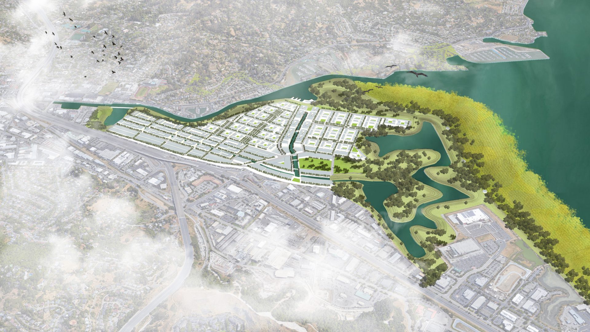
San Rafael_2We approached the physical planning process by combining hard infrastructure features like canals and a creek-facing levee with more organic edges like tidal wetlands along a Bay-facing horizontal levee and floodable parks with the goal of a balanced district for people, animals, and a diversity of water flows. Our phasing was done with the intention to engage local residents in the inevitable change of their own neighborhoods and in acknowledgement of the extremely low threshold for site flooding during both storms and king tides. Redevelopment is intended to meet urgent housing and infrastructure needs while providing a district framework that can continue to evolve with the population, and the water table. Residents, workers, and adjacent communities are served by enhanced transit connectivity and emergency shelter, back up operations, and provisions in case of the occurrence of extreme events.
Canal District Goals:
- Meet immediate housing, infrastructure, and open space needs:
serve as template for evolving district & region
- Multi-benefit water management, habitat, and public spaces: celebrate resilient design
- Provide for hazard adaptation, mitigation & preparedness
Site Context:
Population: 11,918 | Housing units: 3,043 | % of Households Below Poverty: 24% | Open Space: 15 acres
The core of the current San Rafael Canal District is a dense neighborhood primarily occupied by immigrants from Latin America situated within primarily white, wealthy Marin County. It is an area characterized by large numbers of renters at risk for displacement due to high poverty rates, adjacency to the waterfront, and the upcoming arrival of the SMART Train, which is anticipated to draw additional San Francisco commuters to the area. Besides its racial and socioeconomic characteristics being quite different from the county overall, the Canal District is unique in maintaining a stock of market-rate affordable housing. In the heart of the District, apartments built in the 1960s and 70s run in the $200k to $300k range while along the edges to the north and east, single family dwellings easily approach the million dollar mark.
The San Rafael watershed is densely developed from its hills to filled wetlands. The pattern of urban development has constricted San Rafael Creek, limiting its ability to flush sediment and store water in the event of extreme tides or storm runoff. Our entire site lies in a FEMA flood zone. In response to the high liquefaction risk in the area, we have sunk pile foundations through the immediate bay mud to the Franciscan bedrock below.
Phase One | 1.6’ Sea Level Rise:
Site: 674 acres | New Housing Units: 13,148 | Constructed Wetlands: 193 acres | Water Storage: 448.3 acre feet
Rather than continue the current system of underground culverts and trapezoidal channels, our design for an adapted Canal District immediately integrates a connected edge of riparian vegetation with recreational canals, flood ponds, a constructed wetland, and a bay-facing horizontal levee, which will continue to accrete mass as bay mud is deposited via the dredging of the Creek. The placement of our Phase One canals is guided by current site topography as well as the goal of protecting and preserving the residences of the most socially and economically vulnerable district residents. Rental housing will be secured through right of first refusal community benefit agreements with incoming developers. We recognize the current industrial uses present in the area, and extend San Francisco’s PDR zoning designation to allow for the maintenance of a wide range of mixed-use commercial and light industrial businesses, even as housing densities increase, first along the pair of proposed canals and subsequently in the residential neighborhoods that encircle them. The two canals are dug down to below the existing water table and also fed through treated gray water collected on roof tops to to ensure their status as both local amenity and functional infrastructure for storm events. The canals first discharge into the San Francisco Bay through a gravity-directed tidal wetland. As the water table increases in the coming decades, successive pump stations are installed for continued conveyance of water flow out of the site. In addition to serving as a central gathering place with a school, daycare, grocery store, sports facilities, and restaurants, the Community Hub provides emergency operations and provisions in the case of common hazards and extreme events.
Our method to achieve the continued high prevalence of affordable units, especially considering the renter status of their occupants, is to place unit allocation and management responsibilities in the hands of longstanding community advocate organizations such as the Canal Alliance. San Rafael city currently requires new developments to include 10% to 20% affordable units for low and very low income residents, no matter if the units are intended for sale or lease. To immediately alleviate the stress on the housing market in the Canal District, we propose allowing increased density bonuses but disallowing in-lieu fees. In this way, we intend to keep affordable unit availability in pace with overall neighborhood development, securing stability for the existing immigrant population while also enticing new higher-income residents with vibrant, walkable urban design, abundant public open spaces, and transit connectivity to adjacent neighborhoods and the San Francisco peninsula to the south.
Phase Two | 10’ Sea Level Rise
Total Housing Units: 16,262 | Public Open Space: 45 acres | Private Open Space: 44 acres | Water Storage: 1,811 acre feet
Filtration plazas adjacent to and feeding into the central canals serve to daylight the water cleaning and drainage process, creating amenities and educational opportunities out of the functional infrastructure. Some canal water is siphoned for use as gray water throughout the residential and industrial spaces, the rest is released into the wetland and pumped over the horizontal levee. While we anticipate the 101 Freeway to be protected in some capacity by the County and State in the face of sea level rise, our final district build out adds two bridges along the northern edge of the site as well as a ferry terminal for emergency evacuation; the transit infrastructure serves to bolster much-needed connectivity routes to adjacent neighborhoods and the San Francisco peninsula in normal operating conditions. As the district evolves, native flood refuge plant species will mature adjacent to the tidal marsh, providing functional animal habitat under both low and high tide scenarios. Simultaneously, floodable residential blocks will be introduced in phases to increase density in between the canal arteries with corresponding raised roadways. The adaptive floating residential blocks will truly allow district residents to ‘live with water’, meeting the needs of the community while serving as a template for regions around the country and world. Through suspension in retention ponds, the floating blocks also provide resilience in the face of liquefaction threat; they meet the elevated roadways through flexible hinge bridges, with bioswale networks along central thoroughfares. Socioeconomic demographics have been covered above. While current residents of the San Rafael Canal District may be at risk for displacement due to a variety of factors, the high density of the Latinex community is also a potential strength; organizing and engaging local stakeholder expertise is easier than in other areas where community members are more dispersed.