Transit Effectiveness Project
![]()
![]()
![]()
![]()
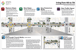
Irving Street Project (Jan 2014) |
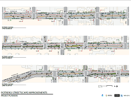
Potrero St Planview (Nov 2013) 53MB |
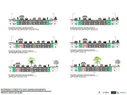
Potrero St Cross-Section (Nov 2013) |
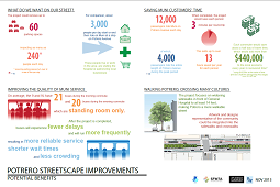
Potrero Ave Benefits (Nov 2013) 53MB |
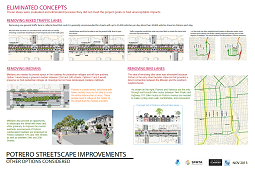
Potrero Ave Eliminated Ideas (Nov 2013) |
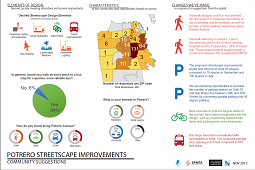
Potrero Ave Community Input (Nov 2013) |
The TEP is a comprehensive overhaul of San Francisco’s transit network that will make Muni more efficient, reliable, safe, and comfortable for its 700,000 daily passengers. In conjunction with other Muni programs, the TEP is a blueprint for improving mobility for all residents while making Muni a great transportation choice for residents and visitors alike. The TEP includes two categories of implementation tools to modernize Muni: 1) "Rapid" Proposals (or Travel Time Reduction Proposals), and 2) Network Service and Route Changes. In addition, the TEP proposes to improve the customer experience by updating maps and investing in new signage to clearly communicate route information.
My role in the TEP so far has been to help translate engineering plans (usually in CAD) into planview and cross-section diagrams that are accessible to the public. By combining the CAD linework with GIS and other data, and adding a bit of artwork, I've created graphics that are an important vehicle for engineers to present their proposals to the public, and for citizens to show engineers the specific places where they have concerns. The hope is that by making these plans more accessible, people will have greater involvement in the process.
The second row of diagrams are sets of infographics that I've created to help convert engineering data into metrics that are more accessible to the general public. A member of the public may not much care that bus headways are being reduced by 5 minutes, but when that is translated into cost savings or less crowded buses, that is much more tangible.
My role in the TEP is ongoing, so I will continue to post examples from it as I complete them and they are released to the public. I've also created interactive maps for SFMTA that are designed to enable residents to see what changes are proposed in their area.