Double parking in San Francisco has become a recurring issue in Bay Area local media. There have been many theories for what has anecdotally become an increase in double parking: inadequate curbside loading, the growth in transportation network companies such as as Uber and Lyft and the growth of residential and job density in some sections of the city. To better understand the issue, I obtained a data set containing over 65,000 parking violations given by parking control officers in San Francisco since 2014.
MAPPING WITH PYTHON/GEOPANDAS
To work the data, I first geocoded the double parking violations based on the approximate address given by the parking control officer. To do this, I cleaned the data in Python and then accessed both Google Maps and Nominatim through an API to convert street addressed into coordinates. After this process, I made a subset of the data based on 5,000 recent entries as a sample. This allowed me to work more efficiently with the data in the initial exploration phase. As the data included the date of the violation, I used a built in function in pandas to identify the day of the week of the violation. This makes it possible to see differences between weekday and weekend violations. This alone provided interesting insight into double parking. The most double parking violations in this sample occurred on a Wednesday (1,194) while the least occurred on Sundays (131).
Next, I did a simple plot of the data onto a basemap of San Francisco county with neighborhood borders. For this map and all of the following maps, I use WGS84 for the projection/coordinates.
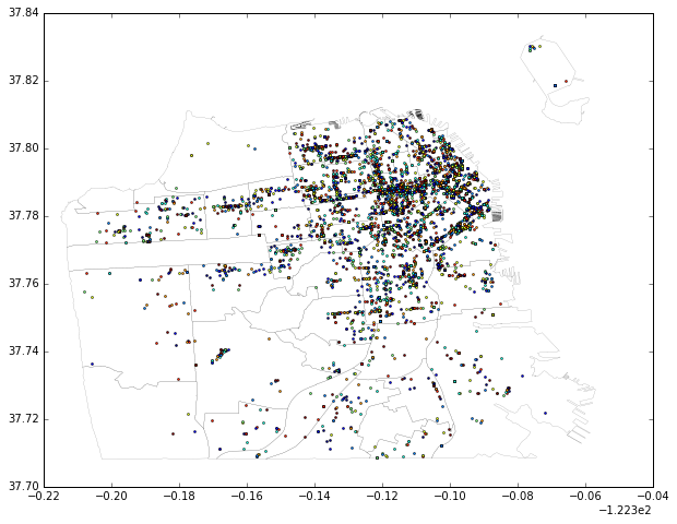
Double Parking Violations in San Francisco: 1/2015 to 08/2016 Sample
Next, I created heat maps of this data based on weekday and weekend offenses.
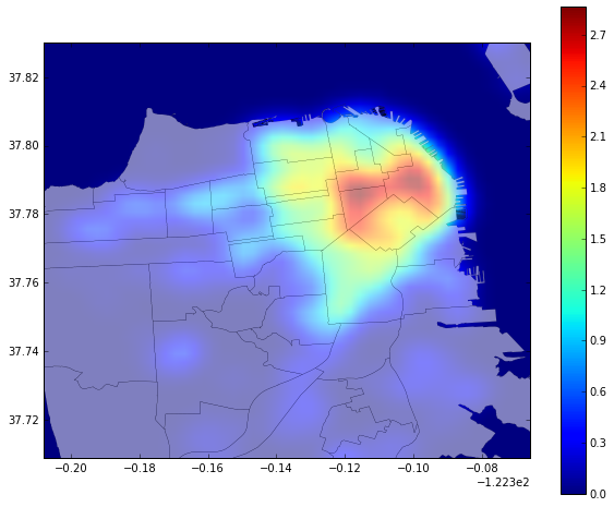
Weekday Double Parking Violations: San Francisco Sample
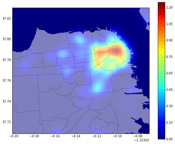
Weekend Double Parking Violations: San Francisco Sample
These maps demonstrate that violations seem to be concentrated in the eastern neighborhoods of San Francisco. While there is some difference between the weekend and weekday maps, this seems to mostly be due to the volume of double parking rather than the areas where it is most present.
DOUBLE PARKING BY NEIGHBORHOOD
To get a better sense of where in San Francisco experiences the most double parking, I performed a spatial join of the basemap with neighborhood information to double parking violations. The results are included below.
Most Double Parking:
- Financial District/South Beach (997 violations)
- Mission (880 violations)
- South of Market (577 violations)
Least Double Parking:
Seacliff, Twin Peaks and McLaren Park all tied for the least amount of double parking violations at 1 violation each.
OFF-STREET PARKING LOTS AND DOUBLE PARKING
Literature on parking violations related to urban freight movement note that some cities have moved forward with providing off-street loading facilities as a way to address loading demand. Could the better utilization of existing parking lots and structures help reduce double parking due to the lack of curbside loading facilities in San Francisco’s eastern neighborhoods? To look into this, I was first curious as to where publicly available parking facilities are actually located. I loaded a data set showing all off street parking lots and structures open to the public in San Francisco. I then created a small buffer around these facilities to demonstrate a reasonable catchment area. As the following map shows, the eastern neighborhoods are well represented by these facilities. Given the concentration of double parking in this area as well as off-street parking facilities, it is worth exploring the possibility of utilizing existing off-street parking space to better serve loading demand in San Francisco.
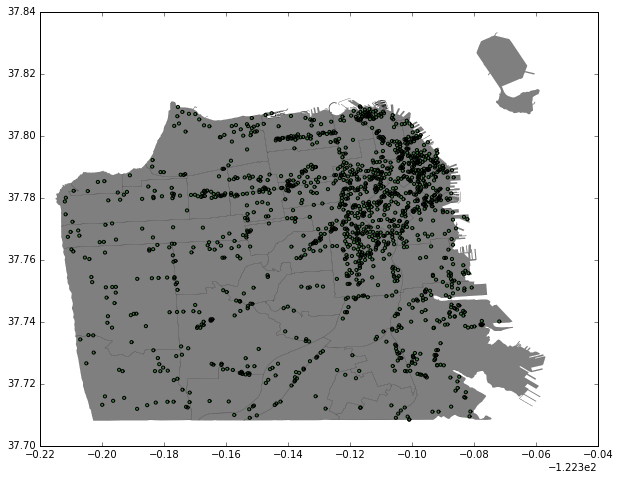
Off-Street Publicly Available Garages with Buffer